Annex "Subtidal habitats"
Research within the “Waddenmozaïek” program
The Waddenmozaïek project is a collaboration between the University of Groningen, the Royal Netherlands Institute for Sea Research (NIOZ) and Natuurmonumenten and aims to shed light on the biodiversity and food web structure of the subtidal Dutch Wadden Sea. Within the project, we map biodiversity and link the benthic communities to habitat characteristics. In order to do so, we conducted a large sampling campaign in 2019 in which samples were taken throughout the Dutch Wadden Sea with a grid resolution of 1 km. In addition, random samples were taken to get better estimates of spatial autocorrelation between sampling locations. Using box cores in the deeper parts and manual long-core samples in more shallow parts, this resulted in data from 1394 samples of which 1303 samples were collected within the study area of the Quality Status Report. Each sample was analyzed by the NIOZ to obtain sediment characteristics; identifications, counts and weights of the benthic species; and stable isotope ratios for the dominant species to reconstruct the subtidal food web. This sampling campaign is scheduled to be repeated in 2022 but is not yet incorporated in long-term monitoring campaigns beyond the duration of the project.
Besides these goals, Waddenmozaïek also tests the feasibility and effects of possible management actions in four subprojects: i) testing the effectiveness of excluding human activities, ii) (re-)introducing hard substrates, iii) identifying structures that can facilitate epibenthic shellfish bed recovery, iv) identifying limiting factors for subtidal seagrass meadow restoration. Overall, the results from the project will improve our understanding of the ecological functioning of the subtidal Wadden Sea and predict the effectiveness of management practices aimed at sustaining or increasing biodiversity.
Long-term bivalve monitoring programs in the Netherlands
The subtidal blue mussel stock is assessed annually in spring since 1992 with a suction dredge along a stratified grid located in the western Dutch Wadden Sea. The area sampled per station is 30 m2. Stations deeper than about 8 m are sampled using a towed bottom dredge (15 m2 per station). Density and biomass of all species (larger than 5 mm) of shellfish, starfish and crabs are registered. Since 2012, a hydraulic grab is used for dense Pacific oyster beds capturing a sampling area of 1 m2. Since 2017, the sampling grid is expanded to include areas located in the western Dutch Wadden Sea and important for Ensis leei as well. In the qualitative autumn survey, a mussel dredge is used. Mussel biomass is not measured but estimated and contours of mussel beds are mapped roughly.
Data acquisition in Lower Saxony
The Forschungsstelle Küste within the Niedersächsischer Landesbetrieb für Wasserwirtschaft, Küsten und Naturschutz (NLWKN) is carrying out a long-term sublittoral mapping program of coastal and marine waters, providing seabed sedimentological and geomorphological data (Figure 23). Mapping activities are part of the sublittoral habitats monitoring, carried out in collaboration with the Nationalparkverwaltung Niedersächsisches Wattenmeer (NLPV) and the Betriebsstelle Oldenburg of NLWKN in charge for biological data. The approach provides full-coverage high-resolution data by means of swath-bathymetrical systems, sub-bottom profiler, as well as validation samples, and integrates bathymetry, reflectivity, and stratigraphy. Bathymetry and seabed images are interpreted using geomorphometric as well as object-based image analysis, to increase the objectivity and generate reproducible results (Mascioli et al., 2017, 2021).
The Scientific Monitoring Concepts for the German Bight (WIMO Project) gave a strong contribution to the development of a methodological concept to map intertidal and subtidal areas. Five test areas have been surveyed since 2010 by coupling airborne remote sensing and hydroacoustic techniques (Capperucci et al., 2020). The Wadden Sea Archive Project (WASA) provided a huge amount of sub-bottom profiles and core data, strongly improving the knowledge on substrates and Late-Pleistocene-Holocene stratigraphical setting (Schaumann et al., 2021; Capperucci et al., 2022).
Sediments and geomorphological data are available for almost all the investigated area. An evaluation with regard to habitat identification as well as morphological and hydro-dynamical modelling is the subject of ongoing work.
 Figure 23: Overview on the mapped areas in subtidal areas of the Wadden Sea and North Sea in Lower Saxony.
Data acquisition in Schleswig Holstein
In the Wadden Sea waters of Schleswig-Holstein, a first area-wide inventory of subtidal sediments, habitats and reef structures has been largely completed (Figure 24). The underlaying hydroacoustic surveys (mainly side-scan sonar) surveys were carried out, among others, within the framework of various collaborative research projects such as AufMod or StopP as well as in the course of numerous research projects in cooperation between the National Park Administration and the Research and Technology Centre Westcoast of Kiel University. In total, an area of about 900 km2 is covered by hydroacoustic data (Figure 24). For ground truthing, approximately 1800 samples were collected and analyzed (as of 2021).
The survey approach is described in detail in a technical report by Ricklefs and Trampe (2021). This paper also presents a kind of catalog describing the characteristics of sonar textures of major seafloor structures of interest. In addition to the initial mapping, identified biological reef structures have also been studied repeatedly over several years. Such investigations on the variability of habitats are now being extended to hard substrates and geogenic reef structures in the context of the just started joint research project WATThochDrei. Here, the focus is on a very close cooperation between geoscientific and bioscientific research that has never been achieved in this form in Schleswig-Holstein tidal flat waters.
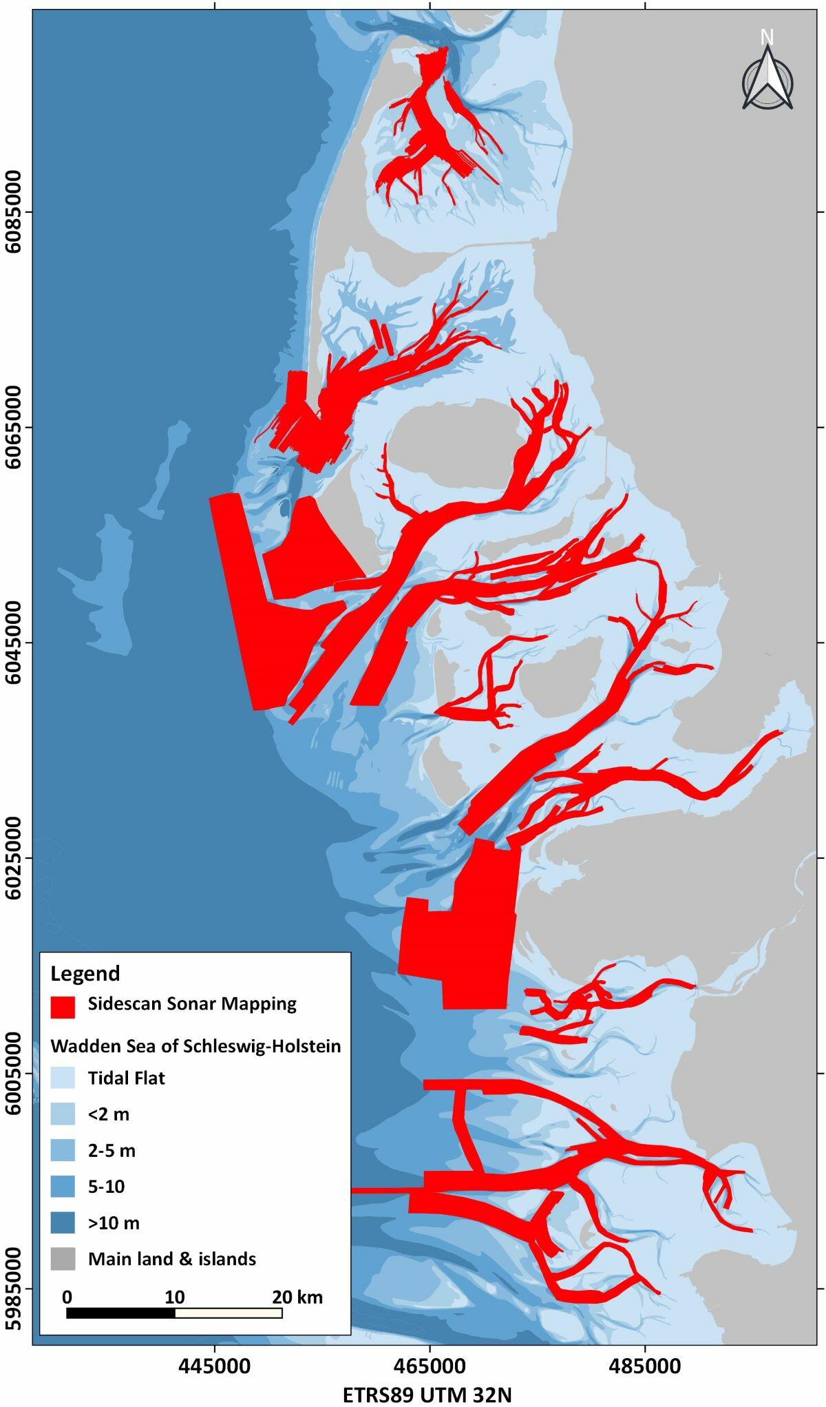 Figure 24: Overview on the mapped areas (red) in subtidal areas of the Wadden Sea in Schleswig-Holstein.
About the problems to access the targets of the Wadden Sea Plan with respect to subtidal habitats
It should be noted that the knowledge base regarding subtidal habitats has broadened since the previous QSR. However, this knowledge is still quite sectoral, both in terms of scientific orientation and spatial allocation. This means that despite partly substantial data and insights in specific research fields the subtidal of the Wadden Sea in all its aspects is still a relatively unknown realm. To achieve an assessment of the targets of the Wadden Sea plan assumes that there is an extensive knowledge and a broad comprehensive database on subtidal habitats of both the historical and present situation. Such a comprehensive knowledge encompassing different scientific fields is not yet available. As an obstacle towards a comprehensive database one may consider varying assignments of the sublittoral to the NATURA 2000 habitat types (EC, 2013) in the different countries. For example, in the Netherlands, the permanently submerged part of the Wadden Sea is assigned to habitat type 1110 "sandbanks". Reefs in the sense of the NATURA 2000 Habitat Directive (type 1170), on the other hand, are not designated (European Environment Agency, 2020). In Denmark, reef structures are part of the Wadden Sea habitat inventory (European Environment Agency, 2020). However, they have not been designated so far (Miljøstyrelsen, 2020). Most of the sublittoral of the German Wadden Sea is assigned to habitat type 1160 "Large shallow bays" (European Environment Agency, 2020). In Schleswig-Holstein, and partly in Lower Saxony, the habitat types 1170 "Reefs" and 1110 "Sandbanks" have already been mapped and assigned.
This mismatch in national knowledge bases makes an evaluation of terms like "natural dynamics", "increased area" or “natural development” very difficult or even impossible for the entire Wadden Sea. The study of "natural dynamics and developments" would require a transnational, comprehensive initial detection, identification, and definition of habitat types followed by a broad long-term monitoring comprising bioscientific as well as geoscientific aspects. First approaches in this direction, carried out in Schleswig-Holstein, showed that e.g. biogenic and geogenic reef structures as well as hard substrates can be considered as hot spots of biodiversity. This suggests including not only mussel beds and Sabellaria reefs, but also reef structures and hard substrates in the Wadden Sea plan target formulations.