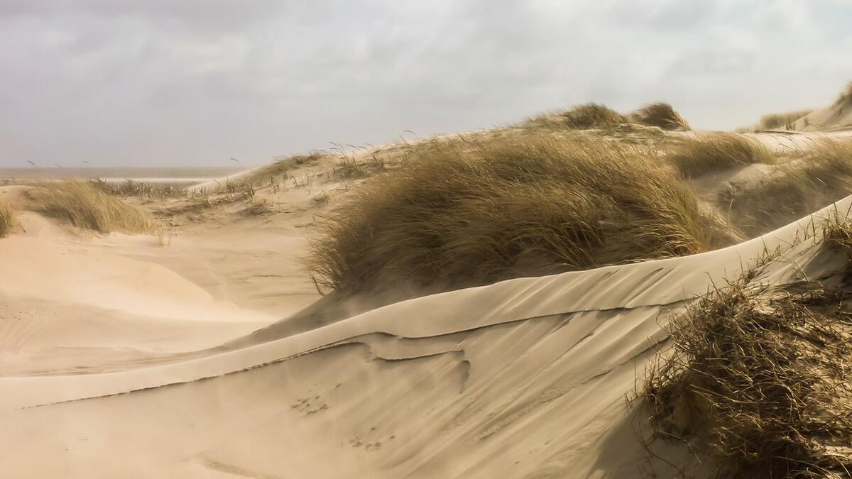
Photo: Alma de Groot. Aeolian sand transport on Rømø.
Beaches and dunes
A.V. de Groot, G.M. Janssen, M. Isermann, M. Stock, M. Glahn, B. Arens, K. Elschot, U. Hellwig, J. Petersen, P. Esselink, W. van Duin, P. Körber, K. Jensen, N. Hecker
Published 2017
1. Introduction
The typically sandy shores of the Wadden Sea Islands and on some locations on the mainland coast consist of the nearshore, surf zone, beach, dunes and dune slacks. Together they comprise a single geomorphic system, called the littoral active zone. It is characterized by sediment transport by currents, waves, and wind and lies between the outer limit of wave effects on bottom stability and the landward limit of aeolian sand transport. Beaches and dunes (including dune slacks), the focus of this report, are mainly found on the North-Sea side of the barrier islands, on small Wadden Sea islands and along the mainland coast at Skallingen and Eiderstedt peninsulas, and near Cuxhaven.
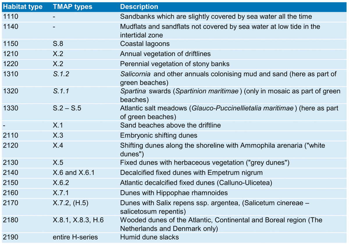
The littoral active zone consists of two ecological systems: 1) the beach, surfzone and nearshore populated by marine biota, and 2) the dune system inhabited by terrestrial plants and animals. Dunes and dune slacks are comparatively high in biodiversity and are home to various endangered species. All beach and dune areas outside human settlements have been designated as Natura 2000 areas under the Birds and Habitats Directives and National Conservation (www.geodienste.bfn.de, www.walterwaddenmonitor.org, arealinformation.miljoeportal.dk). The Natura 2000 habitat types concerned are given in Table 1.
Beaches and dunes are also of importance for coastal defence, recreation, drinking-water extraction, and various other functions (Everard et al., 2010). Beaches, dunes and dune slacks have been modified to various degrees through for example marram planting and sand fences, sand-drift dikes, beach nourishments, revetments, drainage, recreation, and nature management such as livestock grazing, mowing and sod cutting. Still, the Wadden Sea island dunes, particularly those in uninhabited areas, have a far more natural character than those of the mainland dunes along the Northwest European coast (Hellwig & Stock, 2014).
The targets for Beaches and Dunes, as defined in the Wadden Sea Plan 2010, are:
- Increased natural dynamics of beaches, primary dunes, beach plains and primary dune valleys in connection with the offshore zone.
- An increased presence of a complete natural vegetation succession.
In the following text, the targets are slightly adapted so to use the correct wording.
Monitoring programmes mainly concern the dunes, whereas the beach ecosystem is relatively poorly studied and not at all monitored. Therefore, this report will present mostly monitoring results on dunes, whereas assessing beach status remains a challenge. As beaches should be recognised as part of the littoral active zone and of Natura 2000 protected areas, this report gives information on the beach ecosystem as basis for future monitoring, as well as trends in beach nourishments as threat to the beach ecosystem. Additionally, an assessment of the degree of natural dynamics in beaches and dunes is given. For dunes (including dune slacks), monitoring results are given for dune vegetation, invasive plant species, groundwater extractions, and atmospheric nitrogen deposition. There is special attention for the small, uninhabited islands that were underrepresented in the previous QSRs.
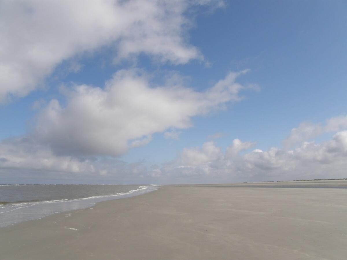 Figure 1. Intertidal beach on Schiermonnikoog (Photo: Gerard Janssen).
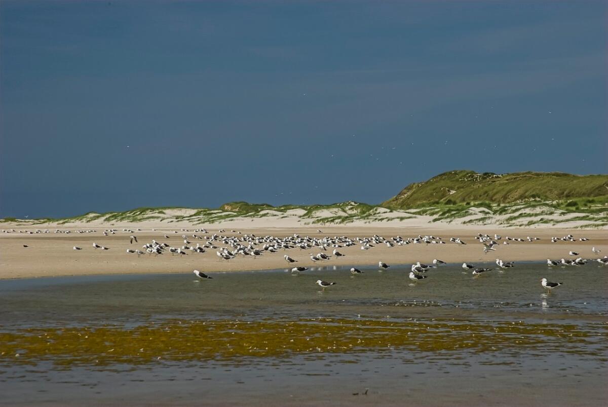 Figure 2. Birds (mainly Lesser black-backed gull (Larus fuscus), using the beach of Amrum as resting place. In the background embryonic dunes (TMAP type X.3) and white dunes (X.4) (Photo: Martin Stock / LKN-SH , 2005).
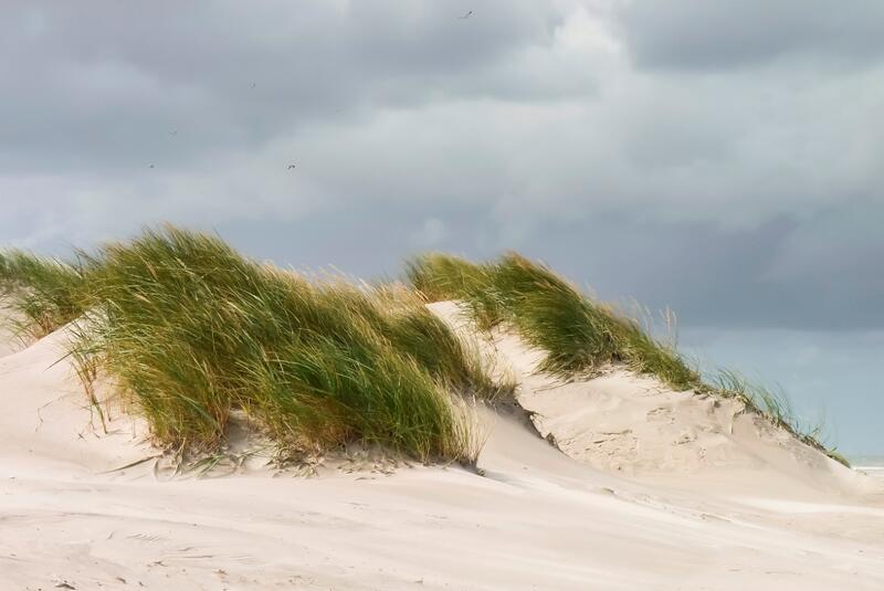
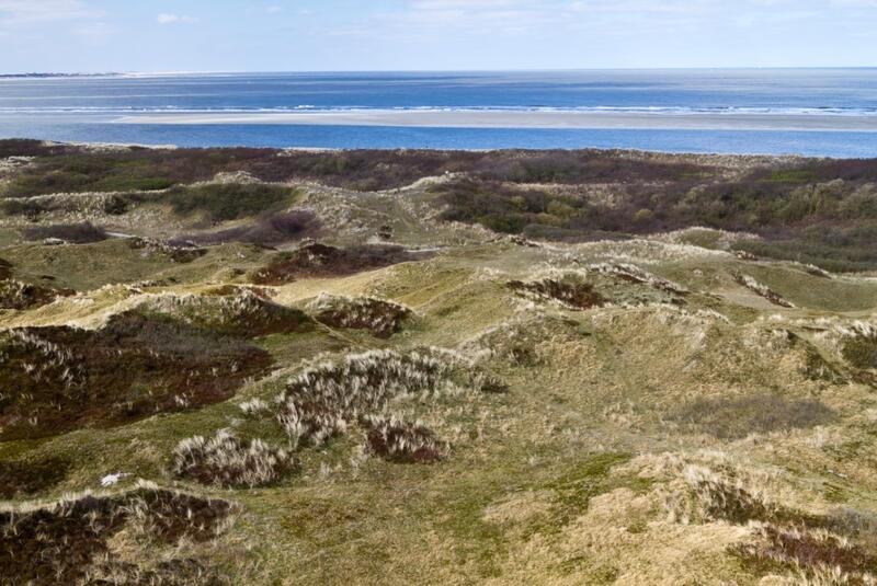 Figure 3. Left (A): White dunes (TMAP type X.4) on Ameland (NL) (Photo: Alma de Groot); Right (B): Mosaic of dune vegetation on Langeoog (Photo: Martin Stock).
Table 1. Natura 2000 Habitat types of the littoral active zone, with their corresponding TMAP vegetation types. For regional differences see the TMAP typology (Source: Petersen et al., 2014).
2. Status and trends
The beach ecosystem
It is not possible to present the status and trends of the beach ecosystem, as there is no trilateral monitoring programme and local data are very scarce. Still, it can be assumed that beaches are overall increasingly under stress of human activities, like sand nourishments and recreation-related activities. This sub-chapter gives a brief description of the beach ecosystem to serve as a basis for the development of a trilateral monitoring plan. As an example, the development of beach habitat areas is given.
The beach ecosystem can be divided into the supratidal and the intertidal zone (Figure 4). The intertidal beach forms together with the adjacent surf zone a nursery area for juvenile (flat) fish. The macroinvertebrate fauna of the intertidal zone is food for juvenile flatfish, shrimp, and several shorebirds. Characteristic macrofauna species of the intertidal beach are the polychaete Scolelepis squamata, the amphipods Haustorius arenarius and Bathyporeia sarsi, and the isopod Eurydice pulchra (Figure 5). Marine algae, plant remains and animal carcasses that drift ashore are the most important resource for secondary production of the beach ecosystem: filter feeders and deposit feeders turn over high amounts of particulate organic matter, and feed on epipsammic bacteria and meiofauna (Figures 5 and 6).
On the supratidal beach, the organic wrack, facilitated by the degradation activities of the Sandhoppers (Talitrus saltator), provides stability and nutrients for pioneer vegetation. In the absence of wrack of marine origin, sandhoppers can also use plant material from dune vegetation as a food source. Further, the supratidal beach is used for breeding by shorebirds and as haul-out and pupping site for seals. Many typical beach-breeding bird species (like several Tern species, Ringed plover (Charadrius hiaticula) and Kentish plover (Charadrius alexandrinus)) have currently low reproductive success (see report "Breeding birds").
The interactions of marine debris, terrestrial debris (e.g. the roots and shoots of Elytrigia juncea subsp. boreoatlantica), and the various parts of the food web make sandy beaches, like salt marshes, an important functional link between the terrestrial and marine environment.
A possible indicator for the area and distribution of beaches could be beach area per island, derived from data that are normally collected for coastal-protection purposes. An example is given for two Dutch islands (Figure 7). Beach area on Schiermonnikoog increased considerably for 150 years, followed by a decline during the past 20 years. On Terschelling, total beach area has stabilised over the past 60 years after an earlier decrease. On both islands, intertidal-beach area increased.
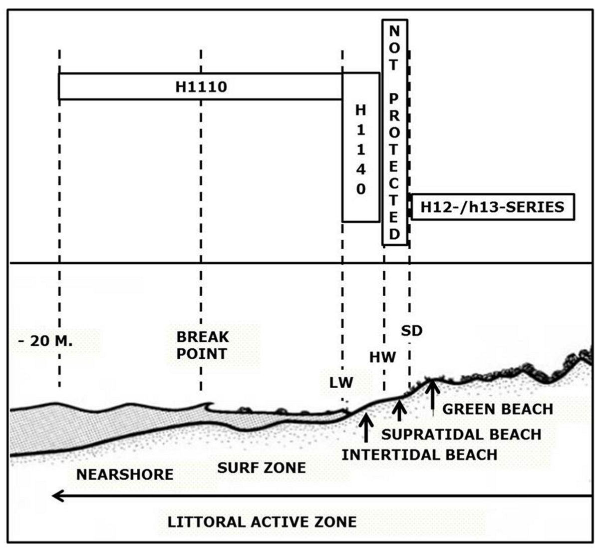 Figure 4. The littoral active zone (after McLachlan & Brown, 2006) with Natura 2000 habitat types. LW = low water linel HW = high water line; SD=storm driftline. The supratidal beach is not or only partly protected under the Birds and Habitats Directive.
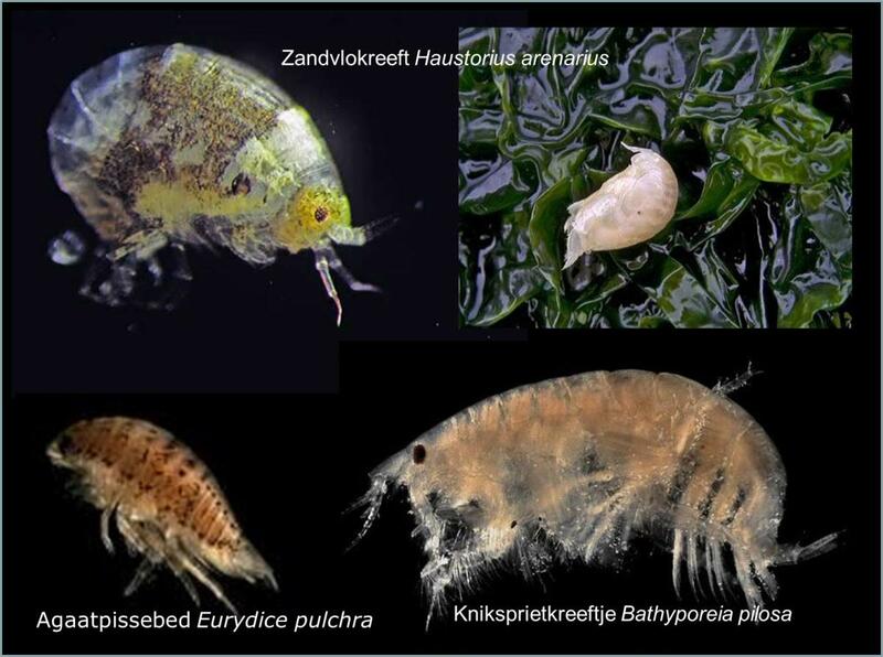
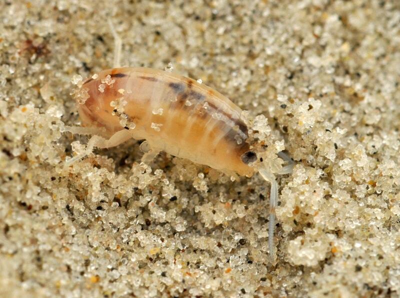 Figure 5. Characteristic faunal species of sandy beaches (Source: Janssen, 2013).
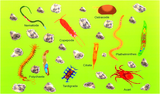 Figure 6. Characteristic components of interstitial (meio) fauna of sandy beaches around Sylt (Image: AWI-Wattenmeerstation Sylt).
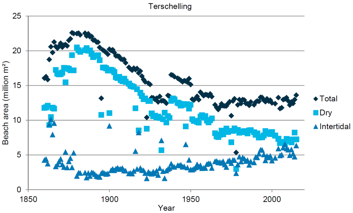
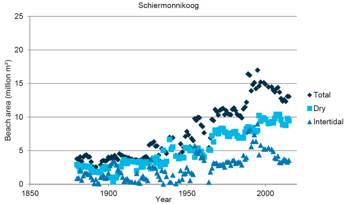 Figure 7. Beach surface area of Terschelling (above) and Schiermonnikoog (below), divided into total, supratidal and intertidal beach (Source: Deltares).
Natural dynamics of beaches and dunes
Dynamic areas, where sand can be transported freely by wind and/or water are an important part of natural beaches and dunes (Petersen & Lammerts, 2005) (Figure 8). The deposited sediment contributes to dune and (to a lesser degree) to salt-marsh growth, allowing the island to grow with sea-level rise (Oost et al., 2012). In a normal’ succession from embryonic dunes to old dunes with climax vegetation, landscape dynamics are generally reduced. Various human activities have further reduced the dynamic area of dunes: e.g. Marram planting, construction of sand fences and sand-drift dikes (Figure 9A), coastal construction works, pine plantations, and atmospheric nitrogen deposition. Sand nourishments and mechanical beach cleaning have influenced natural sediment dynamics. The disturbance by natural dynamics may be an important process in locally creating pioneer settings and thus preserving biodiversity (Oost et al., 2012; De Groot et al., 2016).
Specific monitoring of natural dynamics of beaches and dunes does not exist in the Wadden-Sea region. This text gives a first, qualitative overview of the state of the natural dynamics on the interface between the North Sea and the islands. Further information on the larger scale is given in the report "Geomorphology".
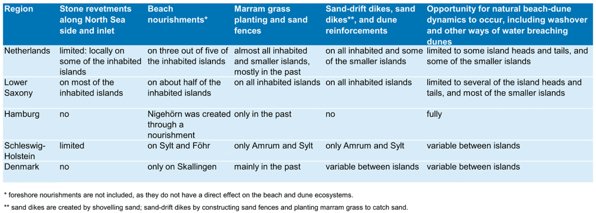
The degree of human interference strongly varies between islands and regions (Table 2). The most important reduction of dynamics is caused by coastal protection works (see also Annex 2 and report "Coastal risk management"). Stone revetments, that strongly fix the position of the coastline, are maintained on most of the Lower Saxony islands, but are not or only limited present in the other regions. Beach nourishments prevent erosional coasts to develop and may facilitate the formation of new embryonic dunes. They are carried out on most of the Dutch inhabited islands, half of the Lower Saxony islands and on some of the Schleswig-Holstein and Danish islands.
Planting Marram grass (mainly Ammophila arenaria and Ammophila baltica) and constructing sand fences in the existing dunes used to be practice throughout the Wadden Sea. The amount of plantings has reduced, but it is still practiced for coastal protection. In the past centuries, many sand-drift dikes were constructed by catching sand in strategically placed sand fences and subsequent marram plantings. Because of their often considerable size (up to kilometres) and placement across washovers, they have strongly reduced the dynamics and altered large parts of the dunes and beaches of most of the islands.
Natural dynamics now effectively mainly occur on the parts of the islands without human settlement, the area of which varies strongly between islands. Most, but not all, uninhabited islands have a larger degree of dynamics than the larger ones. A possible indicator for dune dynamics is the number and area of blowouts (Annex 3).
In the Netherlands, the long-lasting artificial reduction of dune dynamics is currently seen as a threat to biodiversity, natural values and ecosystem services. On Terschelling (Figure 9B) and Ameland, dune vegetation was therefore removed and notches were made in the foredune, so that wind and water may operate more freely on the dunes.
Table 2. Degree of natural dynamics of beaches and dunes per region. Also interventions from the past are included, as far as they still have an effect on the dynamics of beaches and dunes.
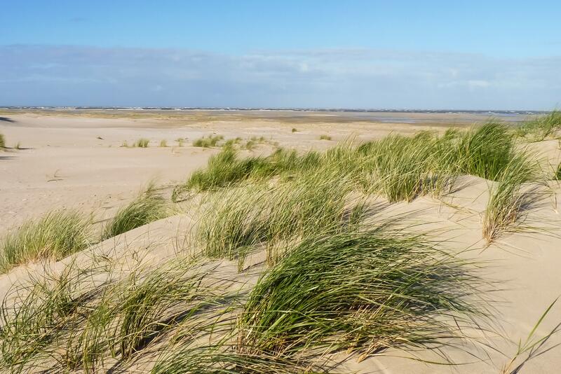
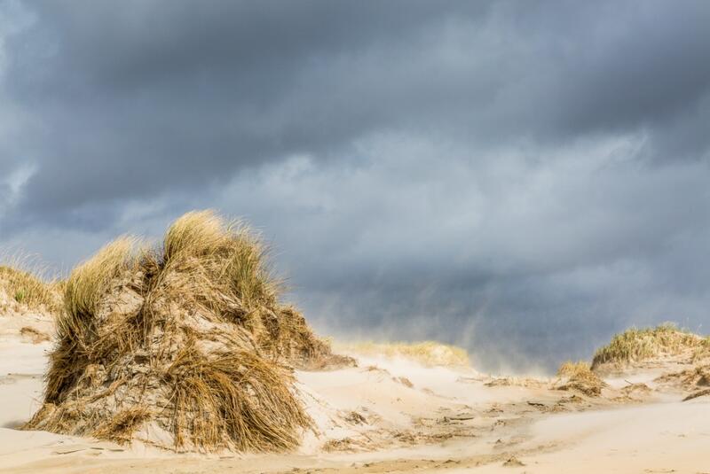 Figure 8. Left (A): Washover on Spiekeroog, where North Sea water floods across the dunes during storm floods (Photo: Alma de Groot); Right (B): Aeolian sand transport on Rømø (Photo: Martin Stock / LKN-SH ).
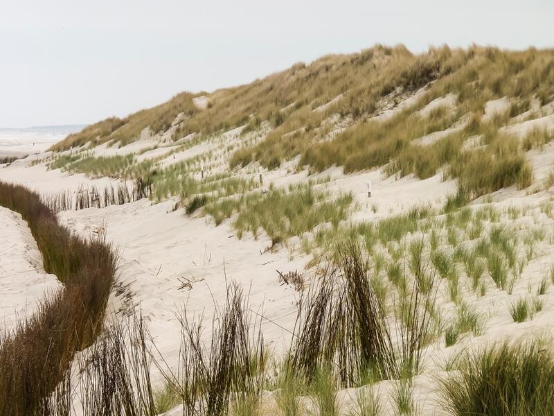
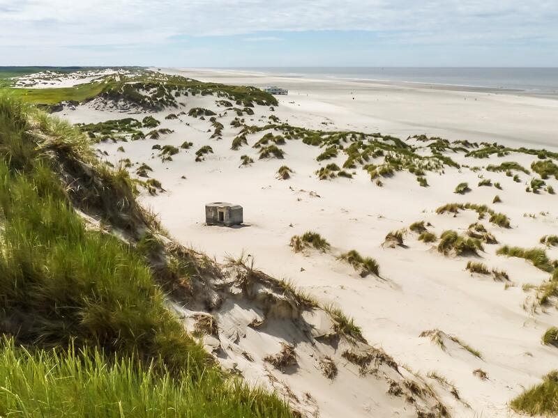 Figure 9. Left (A): Sand fences and marram planting on Ameland; Right (B): Artificially rejuvenated dunes on Terschelling (Photos: Alma de Groot).
Dune vegetation
Dune vegetation occurs in dry dunes and wet dune slacks. In 2014, the TMAP typology of coastal vegetation, i.e. dunes, dune slacks and salt marshes, was finalised so that status and trends in vegetation cover can now be assessed trilaterally (Petersen et al., 2014).
Despite the establishment of the TMAP typology, dune vegetation is mapped differently in the three countries. In Schleswig-Holstein, Hamburg and Lower Saxony, the most recent maps (almost) cover the full TMAP typology. Only Hamburg and Schleswig-Holstein have produced new maps of dune vegetation since the QSR 2009. In Denmark, vegetation is mapped to the level of Natura 2000 habitat types, which is less detailed than the TMAP typology. The mapping of Skallingen is incomplete. In the Netherlands, mapping is done by the individual (nature) management agencies, which may be up to three per island. The various local and regional typologies allow temporal comparison within islands, but none of those fully corresponds with the TMAP typology. Also, not all dune areas are mapped and mapping years vary. The overall detection of trends in vegetation types is further complicated by a change in mapping methods and areas in almost all areas since the QSR 2009 (except for Hamburg), so that a comparison with the data presented in the QSR 2009 and hence trend analysis is not possible. In Germany, the coming mapping survey (2016) will be suitable for comparison with the data presented here.
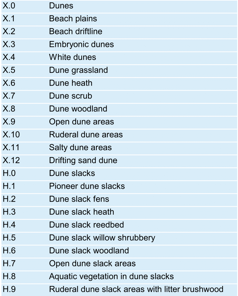
A total of about 20,000 ha of dunes and dune slacks have been mapped in the Wadden Sea region. The area is, with a mapped area of almost 8,000 ha, largest in the Netherlands, even with parts of the dunes not mapped. In Lower Saxony, almost 5,000 ha is present, Hamburg 51 ha, Schleswig-Holstein 4,000 ha and Denmark 3,100 ha (with parts missing). When regarded on the highest typology level (Figure 10), the full successional series is present in each region, albeit in different proportions of the vegetation types. Beach driftline (X.2, Figure 11A) is generally the smallest area, but it is not mapped everywhere (or as part of X.3, embryonic dunes). The area of embryonic dunes (X.3) is almost 300 ha in each of the regions of the Netherlands, Lower Saxony and Schleswig-Holstein, but mapping methods of this type vary. In Denmark the mapped area is very small. Most of the X.0 type (generic dunes) in the Netherlands probably consists of white dunes and dune grassland (X.4 and X.5), so that the proportion of these types to the total area is more or less the same as in Lower Saxony. In contrast, dune heaths (X.6, Figure 11B) dominate in Schleswig-Holstein and Denmark. Dune scrub (X.7) occurs mostly in Lower Saxony, and much less in the other regions. Dune woodlands (X.8) occur mostly in the Netherlands due to pine plantations and Lower Saxony, whereas pine plantations in Denmark are not mapped. The area of dune slacks (H.0, Figure 12B) is highest in the Netherlands and Denmark, and lowest in Schleswig-Holstein. There are variations from this general pattern when the individual islands are considered: an overview is given in Annex 4.
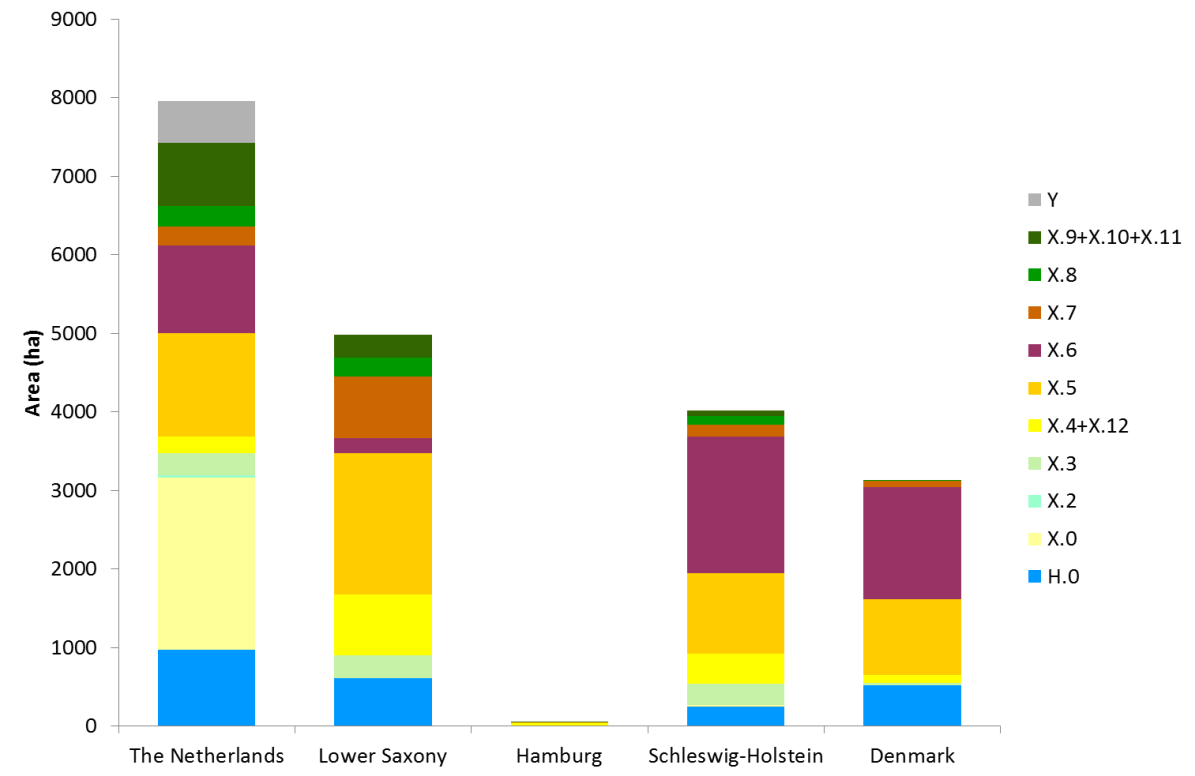 Figure 10. Dune vegetation type per region, both small and large islands. See Table 3 for legend, where Y are types not possible to translate to the TMAP typology. (X.0 consists of dune areas in the Netherlands mapped by RWS, that are not embryonic dunes (X.3) or beach driftline (X.2), and will in most cases be X.4 and X.5). Considerable dune areas of Texel (NL) and Skallingen (DK) have not been mapped.
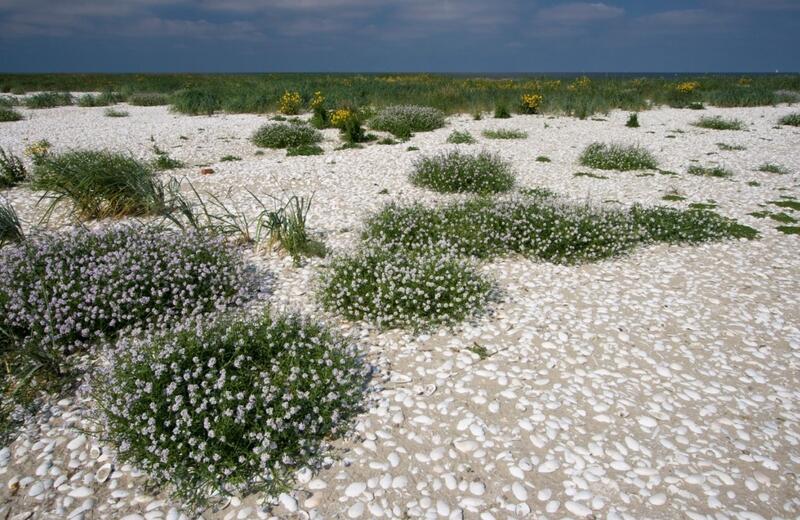
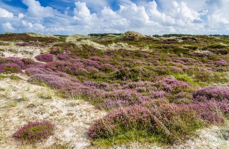 Figure 11. Left (A): Driftline vegetation (X.2) on Trischen; Right (B): Calluna vulgaris type (X.6.2) on Amrum (Photos: Martin Stock / LKN-SH ).
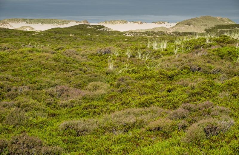
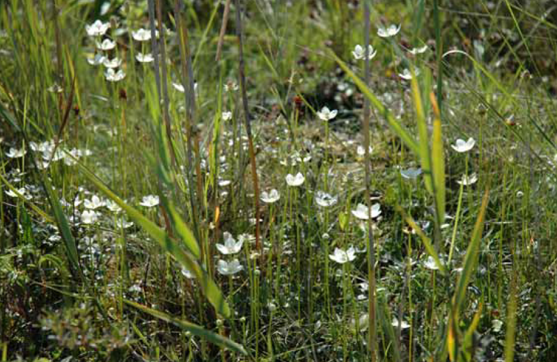 Figure 12. Left (A): Mobile dunes (background) and Empetrum nigrum vegetation type (X.6.1) on Sylt (Photo: Martin Stock / LKN-SH ); Right (B): Parnassia palustris as part of the Schoenus nigricans type (H.2.2) in a dune slack (Photo: Jörg Petersen).
Table 3. Main TMAP vegetation types of dunes and dune slacks (Source: Petersen et al., 2014).
Dune vegetation of small islands
There are various small islands in the Wadden Sea, i.e. sand flats (above mean high water) vegetated with terrestrial plants, that are not inhabited by humans and that are much smaller than their inhabited counterparts. The islands vary strongly in age, location within the Wadden Sea (i.e. more or less exposed), and degree of human influence. More information is given in the report "Geomorphology". The main feature of many of these small islands (often lacking coastal-defence structures) is their highly dynamic nature: they are constantly on the move; shifting rates change over the years and are determined by sediment supply in conjunction with singular, mostly storm-related, events. These islands often have a different history than their larger, inhabited counterparts and may therefore show a very different development. By now, most small islands are part of regular mapping programmes in all three countries (only for Richel, information was derived from another source) and can now be compared as far as the data source allows (see previous chapter). More detailed information can be found in the recent overview of Hellwig & Stock (2014).
The total area of dune vegetation varies considerably between the small islands, with area and vegetation composition reflecting island age and the degree of human influence (Figure 13). Firstly, most are relatively young islands (< 20 years) with mainly X.3.1 (Elytrigia juncea) vegetation: Richel (Figure 14A; Brasseur et al., 2015), Kachelot, Lütje Horn, and Norderoogsand (Figure 14B, part of the Außensände; Stock et al., 2013). The islands of Mellum and Memmert are older and consequently show a larger range of the successional stages. Vegetation on Trischen developed about the same time, but due to its high dynamics there are mainly younger-successional stages present (Figure 15). Rottumeroog and Rottumerplaat are expected to have a similar range of types as Mellum and Memmert, but were not mapped in sufficient detail. Nigehörn and Scharhörn can be seen as intermediate stages. Langli is oldest, and is a remnant of a much larger island, showing a pattern of older successional stages (grey dunes and dune heaths). Griend, also a remnant, will probably look similar if mapped in detail. Minsener Oog was developed as a coastal protection work, and the absence of natural dynamics has given it a dominance of dune grassland (X.5). It is expected that the younger islands will in time develop more successional stages, the fast development aided by the high nutrient input from breeding bird colonies that are frequently seen on the small islands.
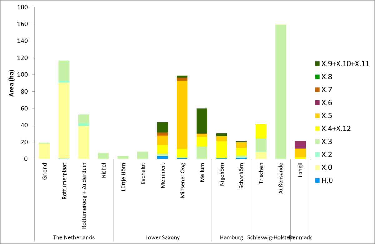 Figure 13. Dune vegetation types of the small uninhabited islands. X.0 in the Netherlands is a combination of all types X.4 to X.12. The area of X.3 of the Außensände is smaller in reality, as the entire area with dispersed embryonic dunes was outlined, instead of mapping only the vegetated area.
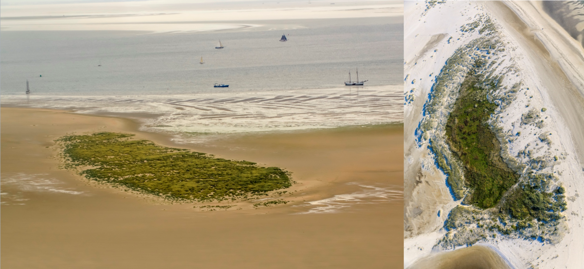 Figure 14. Left (A): The newly-developed embryonic dune field on Richel (NL) in 2014 (Photo: IMARE); Right (B): The island of Norderoogsand (part of the Außensände), 2016 (Photo: Martin Stock / LKN-SH ).
 Figure 15. Washover deposits in the highly dynamic environment of Trischen, Germany (Photo: Martin Stock / LKN-SH ).
Threats: beach nourishments and beach recreation
Beach nourishments (Figure 16) and foreshore nourishments are carried out on several islands in the Netherlands, Lower Saxony and Schleswig-Holstein (see report "Coastal Risk Management"). The volume of beach nourishments on the Dutch Wadden Islands varied between 3 and 13 million m3 per period since 1979 (Figure 17). Compared to the QSR 2009, the volume has increased to 9.6 million m3. Meanwhile, the volume of foreshore nourishments slightly decreased from 14.0 to 13.4 million m3 (not shown). Beach nourishments on Sylt (Schleswig-Holstein) were approximately 6 million m3 between 2009 and 2014, a number that has been relatively stable since the late 1990s. On Norderney, Langeoog, Wangerooge, and Blåvand (Skallingen), beaches were also nourished but with much smaller volumes compared to Sylt and the Dutch islands.
The ecological effects of nourishments on smaller temporal and spatial scales (i.e. years and specific beach sites) can be valued as undesirable (Speybroeck et al., 2006; Janssen et al., 2011) disturbance of breeding birds and burying benthic communities. The most direct negative effect of beach nourishment is the thick layer of sand applied on the beach. Most macroinvertebrate fauna is unlikely to survive a burial of sand of more than 1 m, let alone the more regularly used layers of 3 to 4 m (Leewis et al., 2012). Recovery of the benthic fauna takes place within a few years, but is species-specific (Leewis et al., 2012). Since, at least in the Netherlands, the frequency in which sand nourishments are applied is in the same order as the recovery time, the fauna of nourished beaches are hardly ever in an undisturbed state.
On larger temporal and spatial scales (decades and regions), nourishments both contribute to the formation of coastal habitats (beaches and embryonic dunes), and to the loss of erosional coasts, which would cause natural dynamics of the dunes. In the Netherlands, the ongoing nourishments since 1990 have stopped the coastline from further retreating. As a consequence, the area of embryonic dunes has locally increased and a quarter of the nourished sand is transported into the dunes by wind (Arens & Janssen, 2009).
Recreation (Figure 18) can also negatively influence the beach ecosystem (Defeo et al., 2009), for instance through disturbing and trampling the beach fauna and leaving litter on the beach. Mechanical beach cleaning is often employed as a measure against littering, especially on crowded tourist beaches. The waste is mainly collected manually and transported by machines, but on some German and Dutch islands stretches of beaches are also cleaned mechanically in summer. Mechanical beach cleaning not only disturbs the sand by raking and sieving it, but also removes wrack from the beach (Nordstrom et al., 2012), which is an important resource for supratidal crustaceans and insects. Seedlings and in some cases also mature plants (drift-line habitats) are removed, resulting in a much lower occurrence of habitat type 1210 (Annual vegetation of driftlines). Due to the lack of data it cannot be stated whether mechanical beach cleaning is an increasing or decreasing activity on the islands.
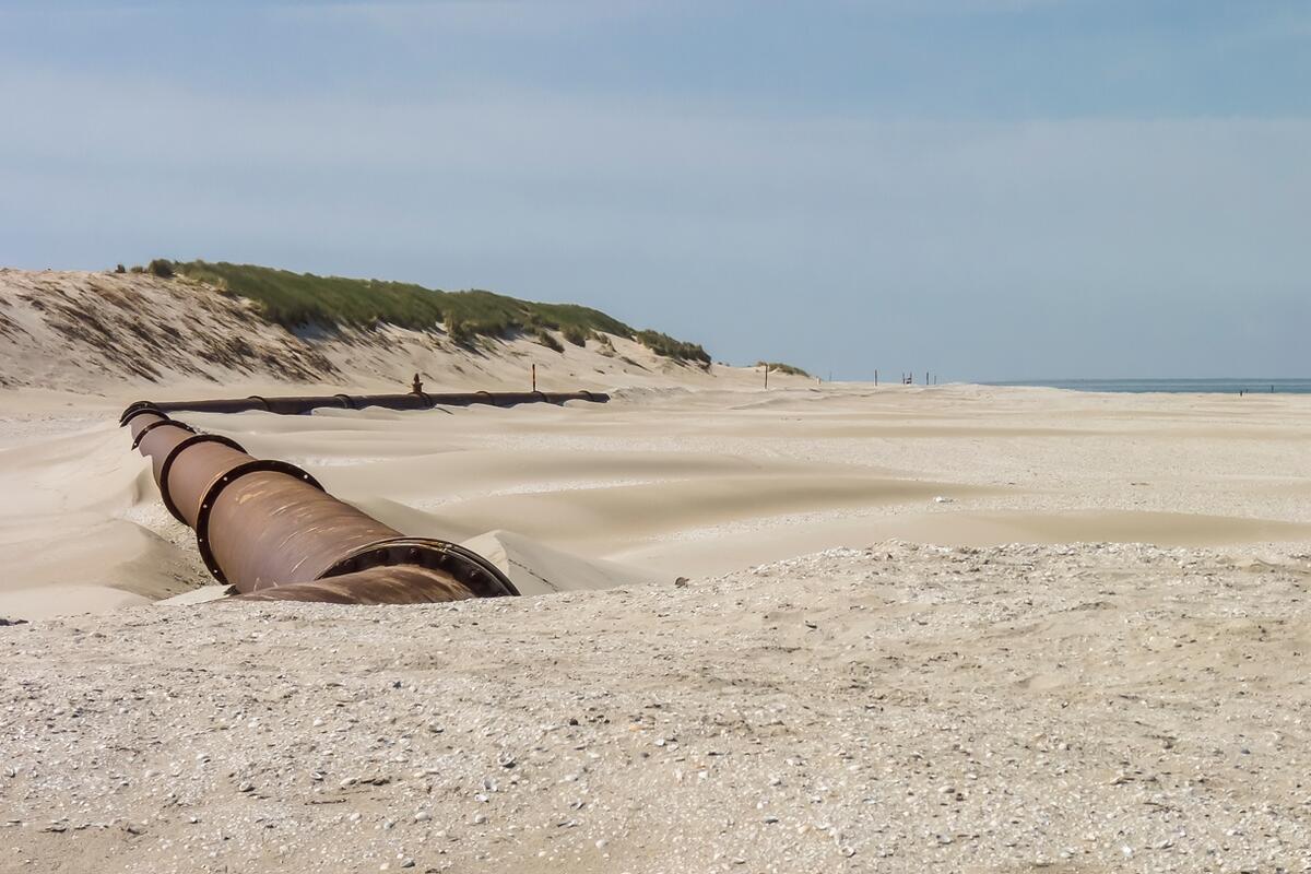 Figure 16. Beach nourishment on Ameland (Photo: Alma de Groot).
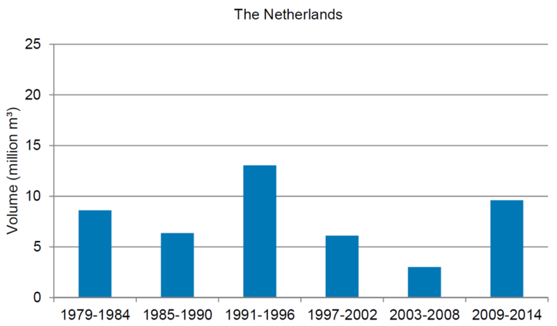
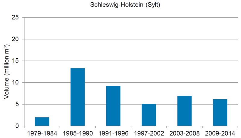 Figure 17. Beach nourishments on the island coasts of the Netherlands and Sylt (Schleswig-Holstein) summed per time period. (Sources: Rijkswaterstaat (Netherlands) and Landesbetrieb für Küstenschutz, Nationalpark und Meeresschutz Schleswig-Holstein).
 Figure 18. Beach recreation on Ameland (Photo: Alma de Groot).
Threats: invasive alien plant species
In dunes and dune slacks, various potentially invasive and invasive alien plant species (IAPS, see also report "Alien species") occur that may affect the dune ecosystem. They are favoured by the relatively dry and warm habitats with high light availability. The low competitive ability of native dune species of nutrient-poor soils, dune fixation and nutrient enrichment (particularly atmospheric nitrogen input) further strengthen the invasion of alien plant species (Sparrius & Kooijman, 2011).
Only few of the IAPS are monitored, so that assessing the extent of the invasions is not always possible. The most well-known and (at least partly) monitored IAPS are Campylopus introflexus (Heath star moss, Figure 19), Rosa rugosa (Japanese rose, introduced as ornamental garden plant, Figure 20), Prunus serotina (Rum cherry), and Pinus spp. (actively planted in pine plantations). They have already been present in the past decades and are currently spreading further. Within the TMAP typology, stands dominated by Rosa rugosa are mapped as type X.7.4, and the pine species Pinus sylvestris, P. mugo, P. nigra (although Pinus sylvestris is considered native in Denmark) in X.8.2. In X.8, Prunus serotina may be dominant, but its cover percentage is not part of the TMAP typology and is only mapped locally. Rosa rugosa (X.7.4 ) covers generally less than 2 % of the total dune area per island, but reaches around 3 % on Sylt and Föhr, and as much as 12 % on Wangerooge (Figure 21). Pinus species cover about 1 % of the dune area per island. These numbers are probably underestimates of the total invasion of these species, because in many cases IAPS may also occur inside other vegetation types and woodlands are often not mapped. There is no correlation between the total dune area per island (Annex 4) and the percentage area covered by IAPS (Figure 21).
The moss Campylopus introflexus was introduced to the Wadden Sea region in the late 1960s and has since then spread in dune areas. There is no separate TMAP type for vegetation dominated by this species, but it is included as one ‘typical’ species in the TMAP type X.5. Recently, Skowronek et al. (2017) used a remote sensing and modelling approach to map its distribution on the island of Sylt. According to this study, Campylopus introflexus has invaded approximately 50% of the area of the type X.5. and 25% of X.6. The model predicted also occurrences in other TMAP types, but due to methodological difficulties, these results should be considered with caution. The study however shows that remote sensing techniques might be a useful tool for the future monitoring of IAPS in dunes of the Wadden Sea region.
Relatively new IAPS that are spreading, but are not mapped yet, are Senecio inaequidens (Narrow-leaved Ragwort) and Crassula helmsii (New Zealand Pigmyweed). These and other invasive alien plant species are described in Annex 5.
Currently, the TMAP typology is insufficient for tracking the invasion of IAPS. For that, the cover percentage of specific IAPS should be scored per mapped polygon.
 Figure 19. Campylopus introflexus (Photo: Maike Isermann).
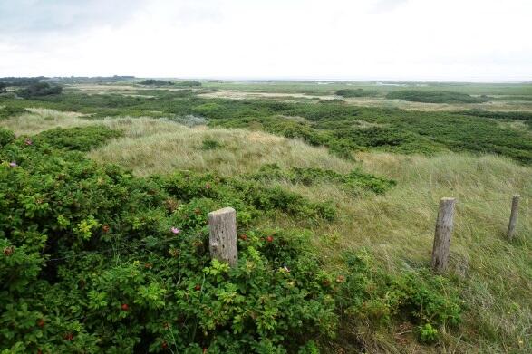
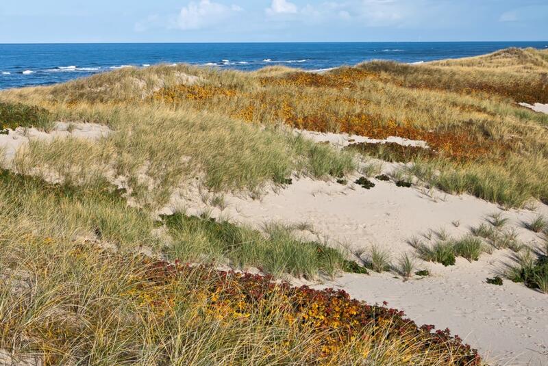 Figure 20. Left (A): Large patches of Rosa rugosa on Wangerooge (Photo: Peter Körber); Right (B): Rosa rugosa (brownish) on Sylt (Photo: Martin Stock / LKN-SH ).
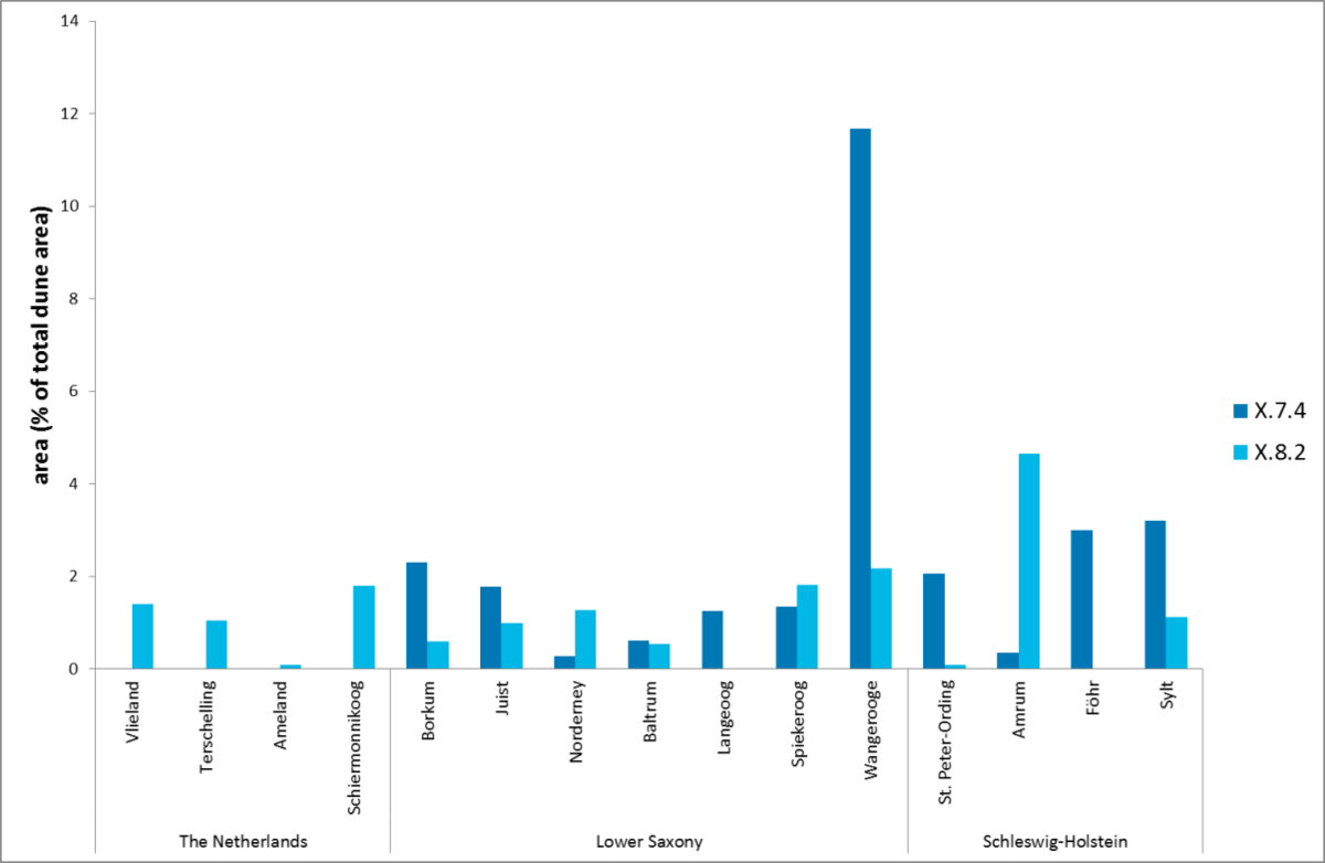 Figure 21. Area of TMAP-types dominated by invasive alien species (X.7.4: Rosa rugosa type; X.8.2: Pinus spp. type) as percentage of the total mapped dune area per island in the Netherlands and Germany. Comparable data from Denmark are not available.
Threats: groundwater extraction
Groundwater extractions affect the hydrological system on the Wadden Sea islands by (locally) lowering groundwater tables and reducing seepage. This may have strong negative effects on dune-slack vegetation (see background information in Petersen & Lammerts, 2005). Consequently, groundwater extractions are under scrutiny in various Natura 2000 management plans, and drinking water extractions have been ended on, for example, Texel and Rømø. An overview of current and historic groundwater extractions is given in Figure 22, as far as data are available. Extractions other than for drinking water, such as by farmers, are not included (i.e. not available), but it is estimated that they may be sizeable in some situations. The exact lowering of groundwater tables and thus the potential effect on the dune ecosystem depends strongly on the local situation (presence of dune slacks, sediment types in the subsurface, topography, vegetation type, location of wells). Biomonitoring is needed to assess the effects, but this is implemented only locally (Lammerts et al., 2009). The given groundwater extractions are consequently used here only as proxy for the potential effect on dune and beach habitats.
In the 1950s, more and more tourists started to visit the Wadden Sea islands, resulting in a growing need for drinking water. Since then, the amount of groundwater extracted increased very fast until the mid-1980s. Currently, there are large variations in the amount of groundwater extracted per island, with Sylt having by far most groundwater extracted. Since the last QSR, extractions have decreased on Fanø, and increased on Vlieland, Terschelling, Schiermonnikoog, and Amrum. Extractions on Rømø were terminated. Elsewhere, the extractions have stayed more or less at the same level. The amount of extracted groundwater is not always related to island size, but also to the number of tourists, management decisions and the availability of drinking water supply from the mainland (the islands with an asterisk in Figure 22). As groundwater extractions have remained more or less stable on most islands, water saving measures have probably been effective. However, most extractions are still at a level that they form a (potential) threat to dune-slack vegetation.
On some German islands, adaptive management of groundwater extraction is implemented. Water is extracted from wells close to wet dune slacks in the wet months, whereas during dry months water is extracted from wells under dry dunes. Such management has lower impact on both the freshwater lens (lower risk of saltwater intrusion) and the ecosystem (less lowering of the water table in the season when the vegetation is most sensitive to drought). The results of biomonitoring on Norderney and Langeoog show that this approach has led to decreasing ecological effects of water extraction (Lammerts et al., 2009). Consequently, it is necessary to organize a trilateral exchange of knowledge on the ecological effects of groundwater extractions, especially on ways to ecologically optimize drinking water production (e.g. by extracting from other locations or deeper aquifers, by applying new desalination techniques on sea water or brackish or salt groundwater) (Lammerts et al., 2009).
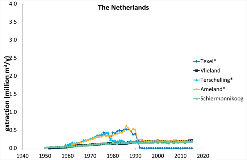
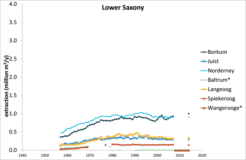
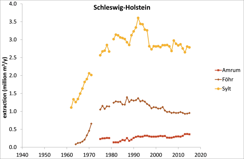
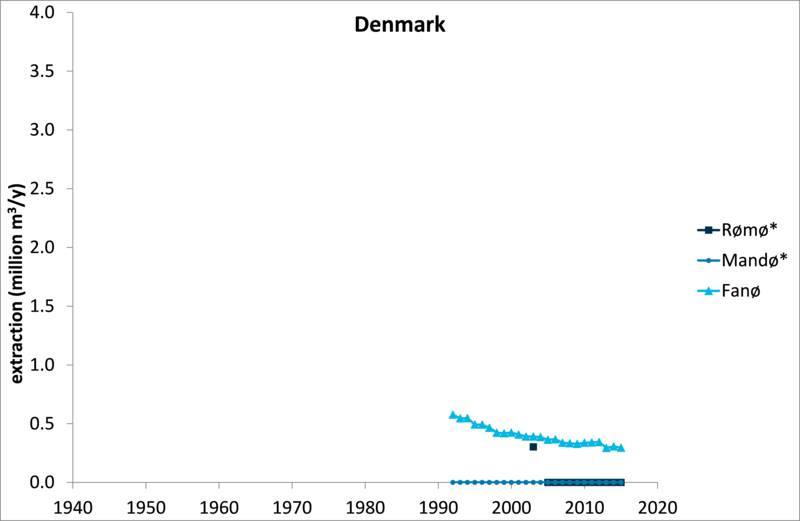 Figure 22. Drinking-water extractions on the Wadden Sea islands per sector (in million m3/year); * asterisks indicate islands that are totally or partially provided with drinking water from the mainland.
Threats: atmospheric nitrogen deposition
Atmospheric nitrogen deposition increased in the 20th century, reaching a peak of ~40 kg ha-1 yr-1 in the 1980s and decreasing again to ~27 kg ha-1 yr-1 in 2002 (Petersen & Lammerts, 2005; Lammerts et al., 2009). Current levels of nitrogen deposition for the dunes of the Wadden Sea islands range between 11 - 18 kg ha-1 yr-1 in the Dutch part, between 9 - 12 kg ha-1 yr-1 in the German part and between 6 - 12 kg ha-1 yr-1 in the Danish part of the Wadden Sea (Figure 23), i.e. a decrease in average level from the Netherlands toward Denmark. Within the Netherlands, deposition values increase from west (Texel) to east (Schiermonnikoog, Figure 24), most likely related to local sources.
Dune habitats are vulnerable to high nitrogen deposition rates, with critical loads set at 10 - 15 kg ha-1 yr-1 for nutrient-poor habitats such as coastal (grey) dunes (van Dobben et al., 2014). Eutrophication due to atmospheric nitrogen deposition can cause grass encroachment and acceleration of vegetation succession (Provoost et al., 2011). In the 2004 QSR (Petersen & Lammerts, 2005), the levels of nitrogen deposition were predicted to be between 6 and 10 kg ha-1 yr-1 in 2010. As these values are below the critical load for the most vulnerable habitats, it was concluded that only local problems would remain, such as high standing crop and large litter layers. For the Dutch islands (Figure 24) both current estimates and model predictions for 2030 indicate nitrogen deposition rates that are still higher than the critical loads of ca. 10-15 kg ha-1 yr-1 for nutrient poor, dry and wet pioneer vegetation types (van Dobben et al., 2014), so that the problem probably remains relevant for the next decades.
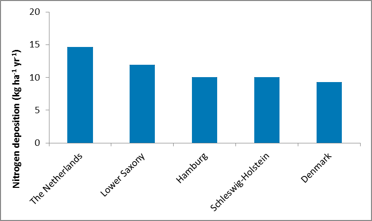 Figure 23. Average nitrogen deposition (kg ha-1 yr-1) on the Wadden Sea islands calculated for the Netherlands (2015, https://monitor.aerius.nl/monitor), Germany (2009, http://gis.uba.de/website/depo1/) and Denmark (2013, http://dce2.au.dk/pub/SR119.pdf).
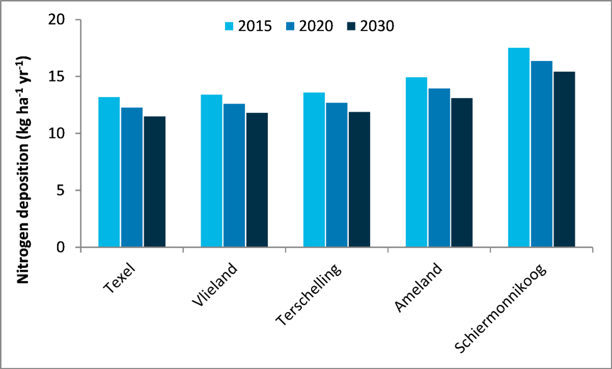 Figure 24. Current and predicted levels of nitrogen deposition for the Dutch Wadden Sea islands from 2015 to 2030 (status 2015, data from https://monitor.aerius.nl/monitor).
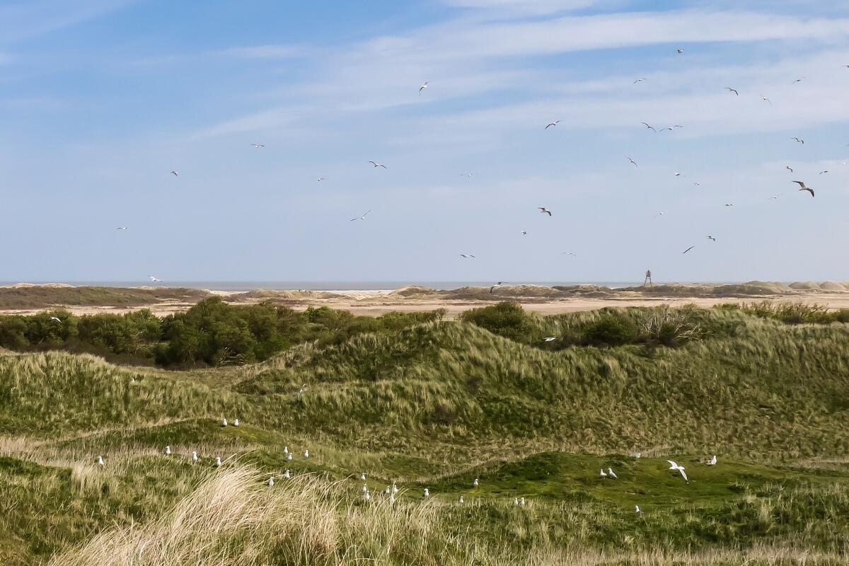 Figure 25. Eutrophied dunes on Ameland through a combination of atmospheric nitrogen deposition and bird droppings (Photo: Alma de Groot).
3. Assessment
Sandwiched between rising sea level on the one side and increasing human activity on the other, beaches and dunes are under pressure (Defeo et al., 2009). The various threats (Figure 26 for the beach) originate from direct or indirect human impact, with coastal protection, tourism, mechanical beach cleaning, and land use as important drivers. Also other human activities and climate change threaten beaches and dunes. The threats are estimated to be at approximately the same level as in 2009. Various mitigation strategies are applied to counteract the effects of the pressures, e.g. sod-cutting, grazing, and mowing; creating notches and vegetation removal of dunes; temporal and spatial zonation of recreation; and obtaining drinking water from the mainland and adaptive well management.
Even after 20 years of trilateral cooperation and the implementation of European nature directives, there is a complete lack of monitoring of the beach biota and not all relevant dune aspects are monitored. Consequently, the trilateral targets for beaches and dunes can only be evaluated partially. In addition to the two targets of the Wadden Sea Plan, the state of the beach ecosystem and ecosystem engineering function are evaluated, given their importance for Natura 2000 and the World Heritage status.
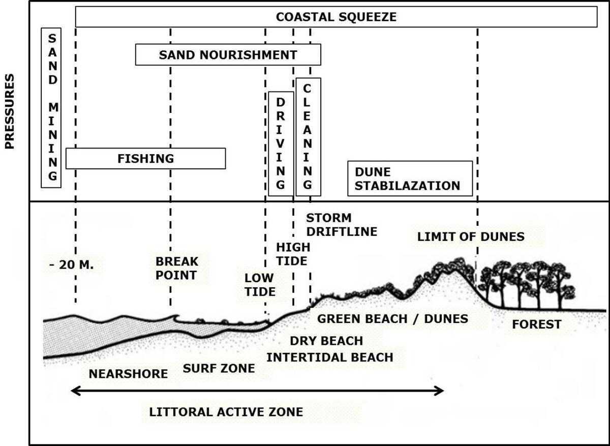 Figure 26. Impacts on the beach-dune system (adapted after McLachlan & Brown, 2006).
Target 1: Increased natural dynamics of beaches, primary dunes, beach plains and primary dune slacks in connection with the nearshore zone
Target evaluation
Many beaches and dunes are affected by anthropogenic influences, such as coastal protection and vegetation planting, that limit natural geomorphic processes and landscape changes. This target aims to increase the area that is under influence of the natural geomorphic and biological processes, and the exchange of matter and biota along the entire gradient of the nearshore zone to the inner dunes. This means that the – often stabilising – effects of current coastal protection measures and other human influences on the coastal ecosystem should be reduced.
Although the target has already been established twenty years ago, there are still no descriptors defined how to evaluate it. Neither is there dedicated monitoring for this target, nor its threats. By using other project measurements, information on some threats could be obtained: beach nourishments, the presence of coastal protection works and vegetation planting, and the number of blowouts in the established dunes (see Annex 3). See also report on "Geomorphology".
Conclusions
- As quantitative data on natural dynamics are largely absent, it is only possible to do a qualitative assessment of this target.
- The following human impacts have negative effects on natural dynamics: atmospheric nitrogen deposition, coastal protection works, dune fixation, drainage and groundwater extraction, recreation-related activities (trampling, buildings, roads, disturbance, golf courses, beach cleaning, etc.) has since long resulted in a loss of dynamic processes initiated by wind and water.
- Trampling by people (recreation) may have both negative (destruction of well-developed habitats, disturbance of wildlife) and positive (increased dune dynamics) effects on the dunes.
- Natural dynamics are currently not, or only limited, present in most dune areas. Only the parts of the islands adjacent to the inlets (e.g. the eastern parts of Norderney and Spiekeroog), small islands (e.g. Kachelotplate, Scharhörn, Trischen) and accretionary shores (Rømø) may exhibit more or less full natural dynamics. This degree of natural dynamics has not markedly increased since the QSR 2009, despite the absence or abandonment of coastal protection (going on for several decades) at these sites. The recent spontaneous formation of embryonic dunes on Richel, Kachelotplate, and Norderoogsand provides a good opportunity for pioneer stages of dunes and salt marshes to develop under fully natural dynamics.
- Recent management interventions in the Netherlands (creating blowouts and notches, Figure 27, and vegetation removal both in the seaward and landward parts of the dunes) allow more dynamics of wind and water into the dunes. This is a good start to counteract stabilising measures taken previously.
- The lower reduction in nitrogen deposition than previously thought increases vegetation growth and therefore the stabilisation of the dune surface by vegetation.
- The effects of long-term nourishments on the large-scale beach-dune system and its natural dynamics are not well known The need for coastal protection will continue under ongoing sea-level rise and climate change. To avoid further reduction of the natural dynamics of beaches and dunes, new coastal protection strategies need to be developed.
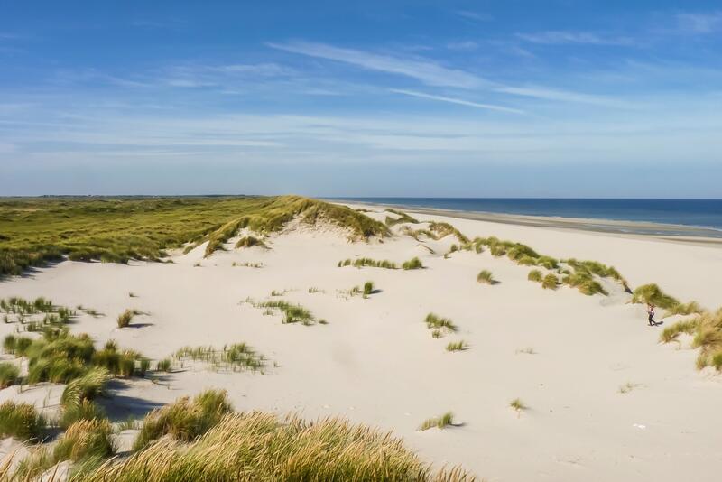
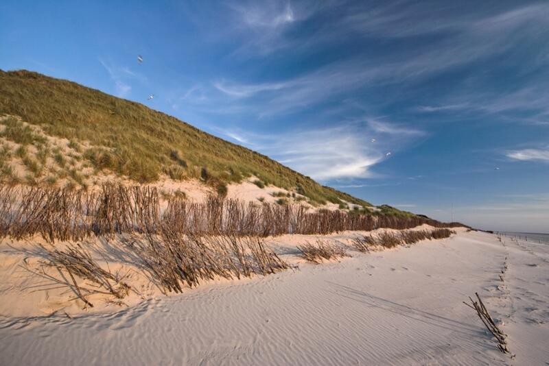 Figure 27. Left (A): Artificially created notch in the foredunes of Ameland (Photo: Alma de Groot); Right (B): Sand fences on Amrum (Photo: Martin Stock / LKN-SH ).
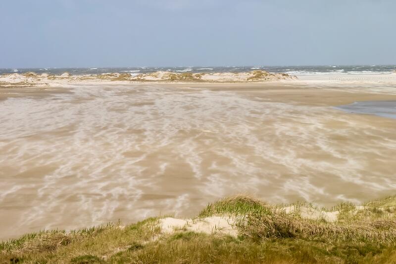
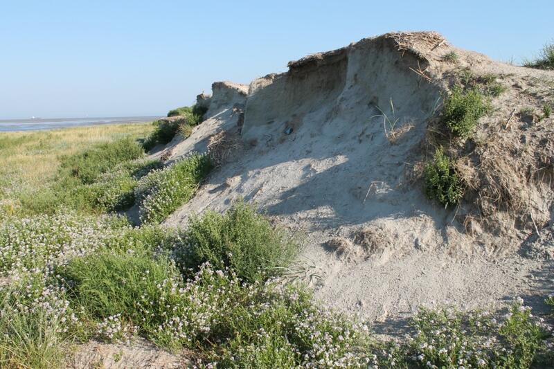 Figure 28. Left (A): Sand transport and naturally developed dunes on Rømø (Photo: Alma de Groot); Right (B): Dune erosion (Photo: Ulrich Hellwig).
Target 2: An increased presence of a complete natural vegetation succession
Target evaluation
A complete natural vegetation succession means that all successional stages of all zones (supratidal beach, dunes and dune slacks) are present within the Wadden Sea, as defined in the TMAP typology (Petersen et al., 2014).
Most relevant areas are now mapped according to the TMAP typology or Natura 2000 habitat types, so that an assessment can be made of the presence of the types. For most areas, mapping methods deviate from the ones used in the QSR 2009, so that the rate of succession could not be described. Monitoring of IAPS under TMAP is not sufficient for unequivocal evaluation and should be improved.
Conclusions
- Most of the conclusions from the QSR 2004 (Petersen & Lammerts, 2005) and 2009 (Lammerts et al., 2009) still stand.
- Dune vegetation monitoring is still on its way in being harmonized and organized trilaterally. On the landscape level, the completion of the TMAP typology of coastal vegetation in 2014 (Petersen et al., 2014) has been an important milestone in this process.In the Wadden Sea area as a whole, the full series of vegetation types (regarded at the highest level of the TMAP typology) of natural vegetation succession is present. However, the entire succession series is not always present on each individual island, because of local differences in management, history, geographical situation and size, that determine the development of specific vegetation types.
- The loss of dynamic processes initiated by wind and water and other human pressures have led to an increased vegetation succession rate and limited rejuvenation or new formation of pioneer situations (from Petersen & Lammerts, 2005).
- Beach cleaning and driving inhibit the establishment of driftline vegetation and embryonic dunes.
- Nitrogen deposition rates are in many instances still above the critical deposition loads. In combination with the amount already deposited, these continue to be a severe problem for the conservation of nutrient-poor vegetation types, including prioritised Natura 2000 habitat types.
- Groundwater extractions remain a threat to the vegetation of wet dune slacks.
- Small, dynamic islands are most likely to develop the complete series of vegetation types in the absence of management and other anthropogenic influences. Their small size, relative youth and dynamics may however limit the possible range of succession stages.
- In all regions of the Wadden Sea area, Campylopus introflexus, Pinus spp., Prunus serotina and Rosa rugosa have been present for a long time and are currently spreading further. The spread of new IAPS is expected.
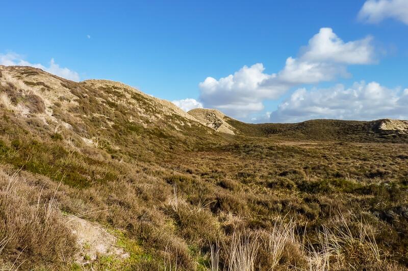
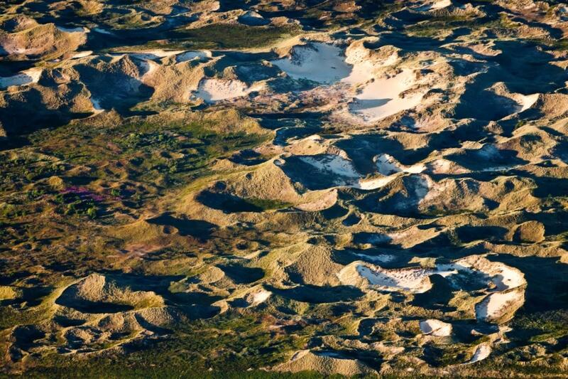 Figure 29. Left (A): Stabilised dunes with dune heath (X.6) on Sylt (Photo: Alma de Groot); Right (B): Dunes on Amrum (Photo: Martin Stock / LKN-SH ).
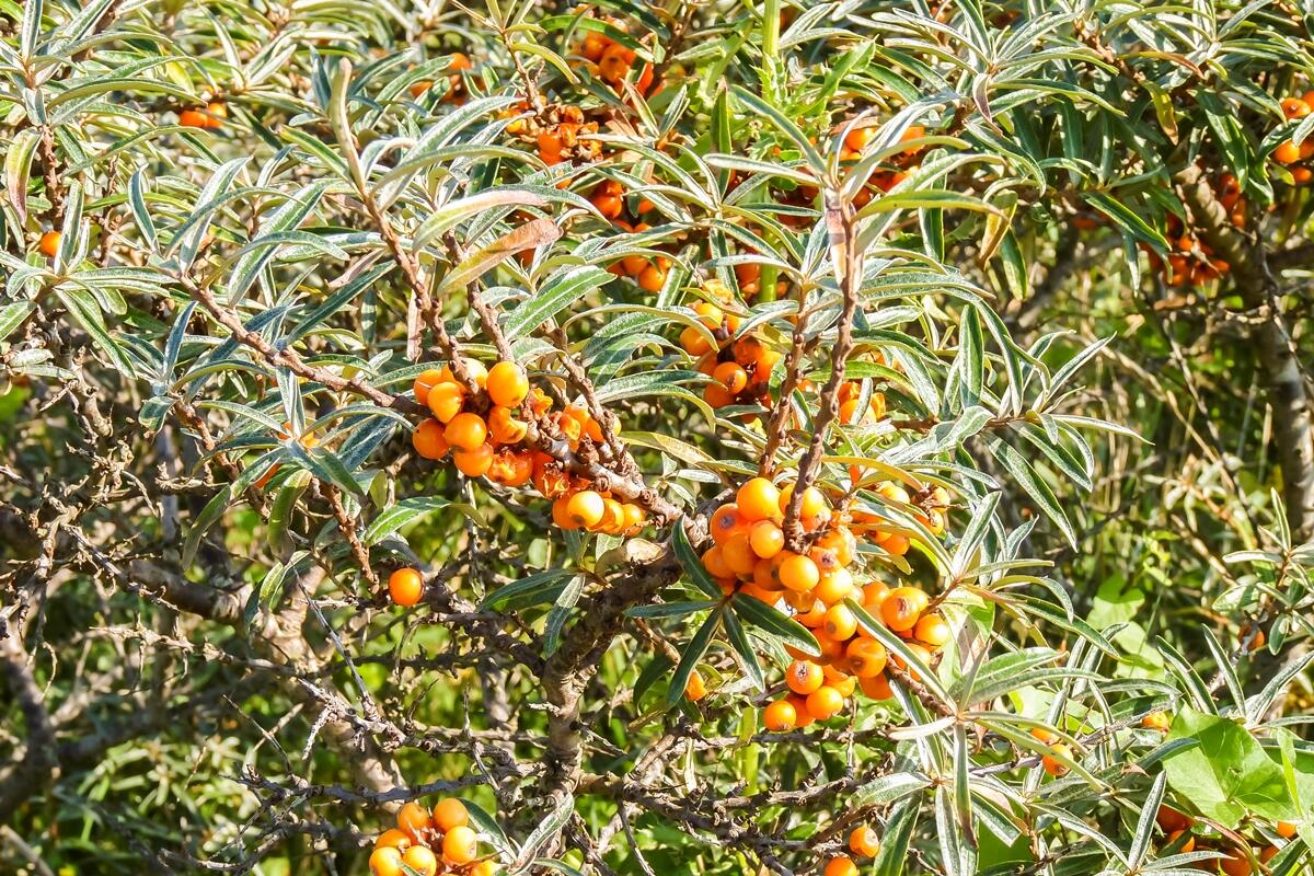 Figure 30. Hippophae rhamnoides (Buckthorn, type X.7.1) on Schiermonnikoog (Photo: Alma de Groot).
Favourable conditions for the beach ecosystem
Evaluation
For beaches, it was already concluded in 2004 and 2009 (Lammerts et al., 2009; Petersen and Lammerts, 2005) that there was insufficient knowledge about the actual status of beaches in the Wadden Sea to evaluate Target 1 (natural dynamics) of the WSP 2010. A trilateral target for the state of the beach ecosystem is however lacking. Within Natura 2000, national targets have been defined for the intertidal beach, but they are not trilaterally coordinated. These targets range from conservation of the actual status to improvement of quality and area. Since monitoring is lacking, the Natura 2000 targets cannot be fully evaluated at this moment. For the supratidal beach, no targets are formulated within Natura 2000 nor in the Wadden Sea Plan. This is considered as a lack, and therefore we do a short assessment here.
Conclusions
- A trilateral target for the state of the ecosystem of the intertidal and supratidal beach is missing and should be developed.
- As monitoring data on beaches are largely absent, it is not possible to do a quantitative assessment of the beach ecosystem.
- The supratidal part of the beach is not part of any Natura 2000 habitat type, whereas it has large ecological value as part of the continuum from sea to land, its use by birds, seals and interstitial fauna, and it being the basis for the development of dunes and green beaches.
- On the beaches, beach driving, mechanical beach cleaning, and trampling cause the disturbance and even destruction of pioneer dunes and beach fauna.
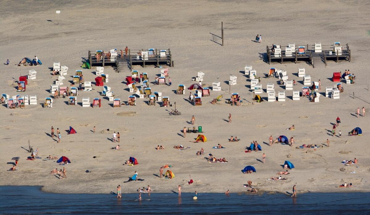 Figure 31. Beach recreation on the sandy shore of St. Peter-Ording (Photo: Martin Stock / LKN-SH ).
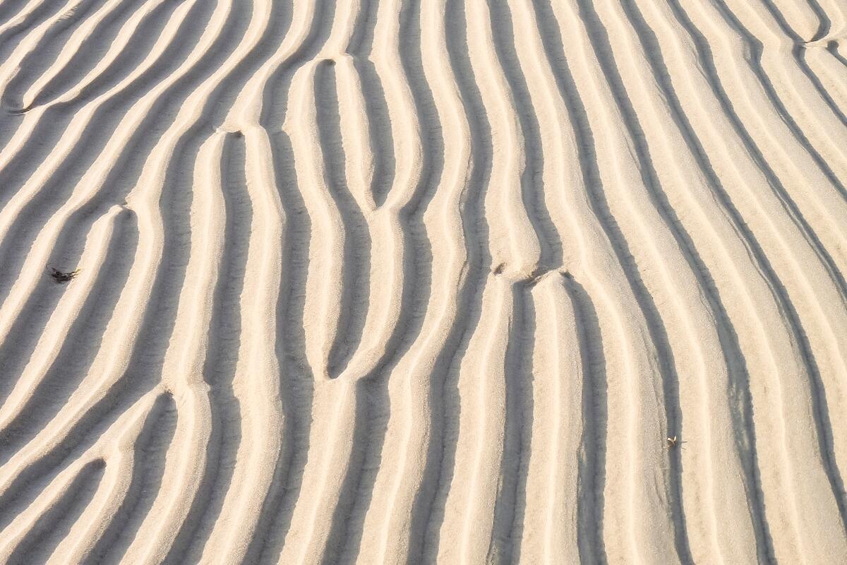 Figure 32. Ripples on the intertidal beach of Texel (Photo: Alma de Groot).
Well-functioning ecosystem engineering processes
Not in the Wadden Sea Plan, but of importance in the context of the World Heritage Status, is ecosystem engineering functioning: whether the unique natural processes that shape the Wadden Sea region, and more specifically the biogeomorphic interaction between sediment and organisms, are functioning well. For dunes that means whether dune formation (sand transport and vegetation growth) and dune dynamics are functioning naturally and unobstructed (e.g. Figure 33). Dunes are typical examples of biogeomorphic systems that are strongly shaped by the interaction between Ammophila arenaria, Leymus arenarius, Ammophila baltica and Elytrigia juncea (Elymus farctus) and sand transport by the wind. Dunes with these species (X.3 and X.4) cover large surfaces (Figure 10). However, as mentioned before, due to Marram planting and sand fences, natural dynamics have diminished. Beach cleaning and driving further pose a threat to new establishment of ecosystem engineering dune grasses. Hence the species themselves are not under threat, but the natural ecosystem engineering functioning has been somewhat altered.
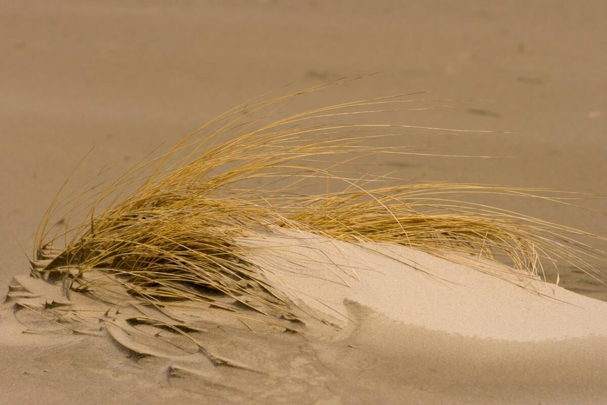 Figure 33. Marram grass (Ammophila arenaria) catching sand on Spiekeroog (Photo: Martin Stock / LKN-SH ).
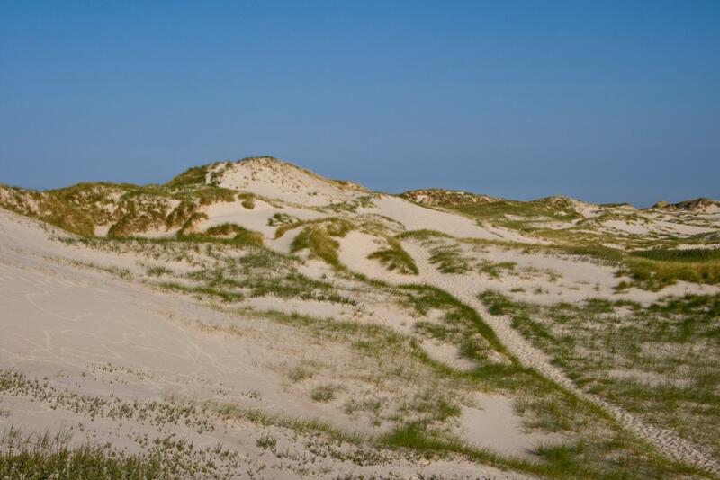
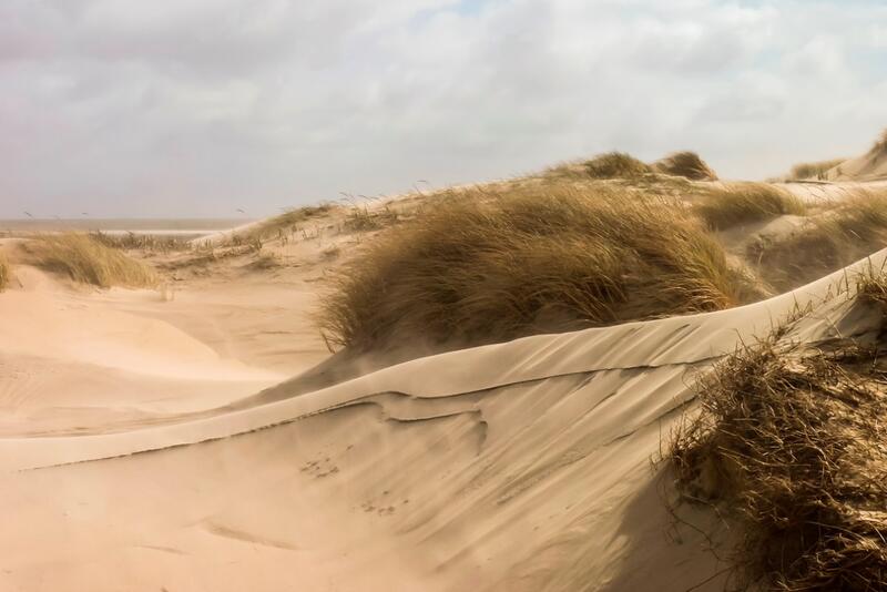 Figure 34. Left (A): White dunes on Amrum where dune grasses capture the sand blown in from the beach (Photo: Martin Stock / LKN-SH ); Right (B): Aeolian sand transport on Rømø (Photo: Alma de Groot).
4. Recommendations
The current targets as given in the Wadden Sea Plan 2010 do not cover all trilaterally relevant aspects of the beaches and dunes. Therefore it is recommended to improve the targets, both in wording and in contents, as applied in chapter 3. The current targets should be complemented with additional targets on the beach ecosystem and the dune fauna, to be developed in the Salt Marshes and Dunes Expert Group.
Recommendations for science and monitoring
- Relevant indicators and beach monitoring should be designed and implemented trilaterally as soon as possible. Beach research and monitoring should present information on area and quality of the beach habitats, and include both abiotic and biotic parameters, as well as information on the various pressures resulting from human activities. The details of how to do this need to be developed. An example would be the evaluation of status and trends in beach surface area, similar to the vegetation types of dunes and dune slacks.
- Dune vegetation monitoring should be further harmonized. Currently, only Schleswig-Holstein and Hamburg follow both the advised TMAP typology and mapping interval of six years or less. In the Netherlands, mapping efforts need to be adapted such that they include the entire vegetated dune areas, have intervals of six years or less, and use typologies that can be unequivocally translated into TMAP types. If possible, the islands should be mapped as a unit, i.e. salt marshes, beaches and dunes in one mapping effort. The mapping in Denmark should be improved by adopting the more detailed TMAP typology instead of Natura 2000 habitat type. Vegetation monitoring should be further improved by the following:
- Evaluate existing detailed vegetation monitoring programmes, i.e. permanent quadrats such as the NOVANA monitoring programme in Denmark, on their use for the assessment of vegetation status and trends.
- Monitoring of (potentially) invasive plant species should be implemented trilaterally, given the current uncertainty around the degree of invasion.
- Monitoring of rare plant species should be decided on and implemented trilaterally.
- For all regions, information on management type (grazing, sod cutting, etc.) and drainage should be included in the vegetation mapping, similar to the salt marshes.
- The use of UAVs (drones) may improve monitoring detail and reduce costs.
- Monitoring of target fauna species (e.g. the Natterjack toad, Bufo calamita, in primary dune slacks) is lacking and should be decided upon. Unfortunately, very little is known about the role of fauna groups within dune ecosystems, so that it is difficult to define functional fauna groups, let alone to select the indicative species for such groups (Lammerts et al., 2009).
- Monitoring of beach and dune dynamics should be designed and implemented, to be able to evaluate Target 1. This could, for example, include the presence of washover-type features, management interventions, and blowouts/shifting sands mapped as separate units. Information on the growth and erosion of dunes (including dune-foot dynamics) can be derived from existing physical monitoring programmes.
- Groundwater extractions other than drinking water extractions should be included in monitoring. The (potential) effects of groundwater extraction should be evaluated by relating the actual extractions to the size of the freshwater lens per island. Additionally, it should be evaluated if there are by now sufficient data that show the area affected by the extractions.
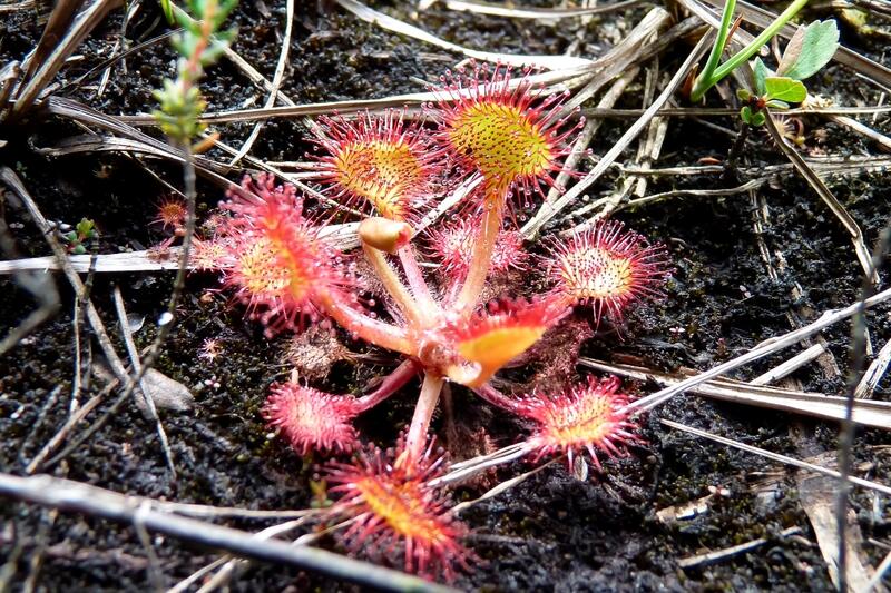
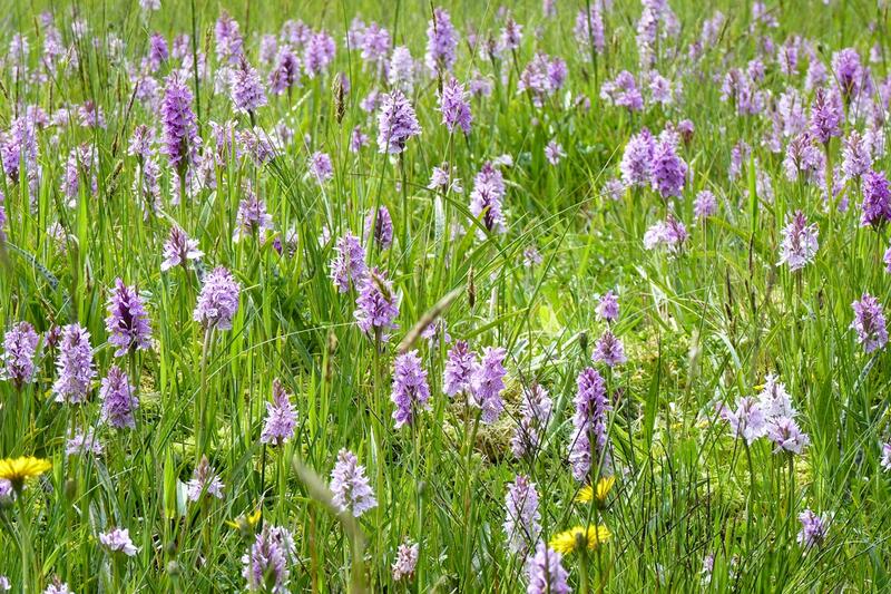 Figure 35. Left (A): Drosera rotundifolia on Terschelling; Right (B): Dune slack with orchids on Terschelling (Photos: Alma de Groot).
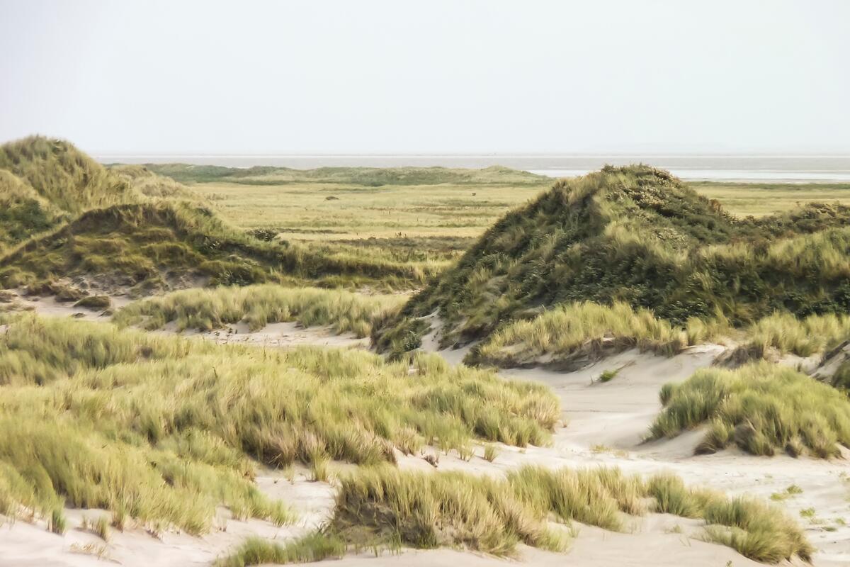 Figure 36. Naturally-formed dunes on Ameland (Photo: Alma de Groot).
Recommendations for management
None of the –still valid– recommendations for beaches in the QSRs of 2004 and 2009 (Petersen & Lammerts, 2005; Lammerts et al., 2009) have yet been implemented. This is a worrying development which calls for trilateral action.
Moreover, the unvegetated supratidal beaches are not designated as Natura 2000 habitat types. Depending on national laws, this essentially means that part of the littoral active zone is not always under nature protection and therefore not everywhere protected as an ecological unit.
It is recommended to:
- manage the “active littoral zone” as a coastal entity;
- add the dry, supratidal beach habitat to the protected habitat types within the Natura 2000 framework, and coordinate the protection of the N2000 beach habitat types on a trilateral basis;
- protect more beaches from human disturbance: for fauna during the bird breeding season and the seal pupping and moulting seasons, and for vegetation so that embryonic dunes may establish;
- mitigate the main pressures on the beach ecosystem: mainly recreation and beach nourishments.
The reduction of dune dynamics as a result of coastal protection works and atmospheric nitrogen deposition should receive more attention trilaterally. In the Netherlands, various dune reactivation projects are carried out. Here, care should be taken that also the older, sometimes unmanaged successional stages have natural values and should be part of the landscape, too. In Germany and Denmark, care should be taken that valuable dynamic areas will remain and not become fixed.
Groundwater extractions have remained more or less constant since the QSR 2009 (Lammerts et al., 2009). Water preservation policy should be continued and where possible intensified, so that drought pressure on wet dune slacks can be further reduced. Where possible, well management with biomonitoring (Lammerts et al., 2009) should be adapted such that the impact on sensitive dune-slack vegetation is minimised.
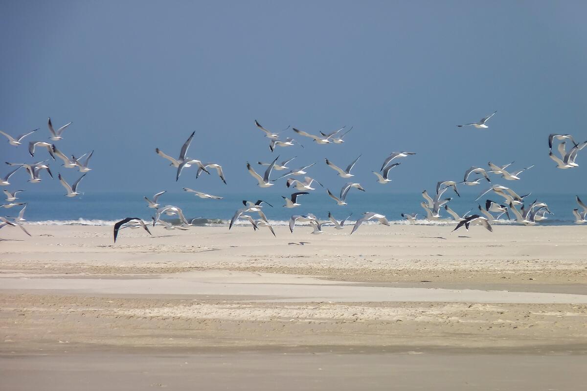 Figure 37. The intertidal beach of Schiermonnikoog (Photo: Alma de Groot).
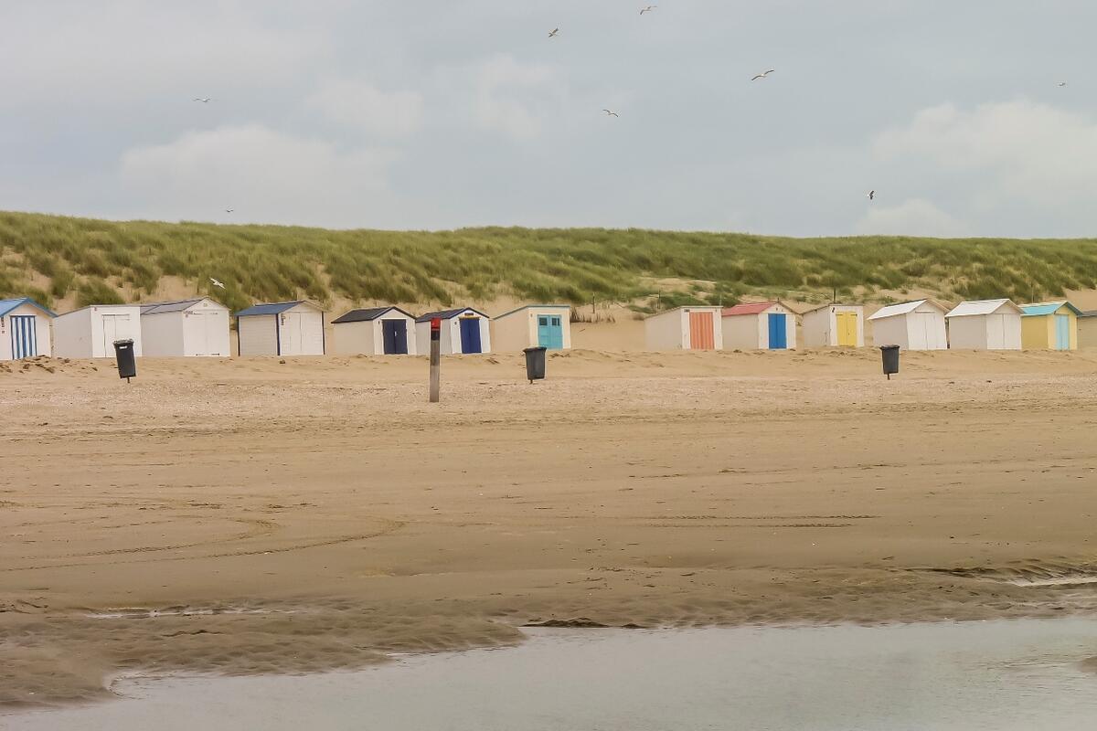 Figure 38. Beach houses on Texel (Photo: Alma de Groot).
5. Summary
Beaches and dunes form the sandy outer side of the Wadden Sea area and contain a variety of habitat types. Beach area and ecological status are currently not monitored. Dune-vegetation monitoring is increasingly harmonised trilaterally, but not all time series are consistent and trends can therefore not be identified, yet.
Status and trends
- Natural dynamics of beaches and dunes occur mainly on the uninhabited parts of the barrier islands without coastal protection, and on small uninhabited islands. In the Netherlands, dune activation projects are carried out to increase dynamics.
- A total of about 20,000 ha of dunes and dune slacks were mapped in the Wadden Sea region: approximately 8,000 ha in the Netherlands, 5,000 ha in Lower Saxony, 54 ha in Hamburg, 4,000 ha in Schleswig-Holstein and 3,000 ha in Denmark. Almost all are located on the barrier islands. The relative occurrence of vegetation types varies between islands and regions. The small islands in the Wadden Sea exhibit a large range of dunes differing in age, dynamics and vegetation types. Invasive alien plant species encroach in the dunes and dune slacks, and the TMAP monitoring should be improved to include these developments.
- Beach ecological status cannot be reported, but information on beach nourishments and recreation indicate that this ecosystem is under pressure.
- The various threats to dunes and beaches are estimated to be at approximately the same level as in 2009.
- Groundwater extractions and atmospheric nitrogen deposition have in most instances not, or marginally, decreased since 2009, and therefore still have (in some cases potentially) negative effects on the dune vegetation.
Assessment
Target 1: Increased natural dynamics of beaches, primary dunes, beach plains and primary dune slacks in connection with the nearshore zone
- This target still lacks descriptors and dedicated monitoring.
- Qualitative interpretation shows that the combination of nitrogen deposition, coastal protection works, dune fixation, drainage, and recreation-related activities and buildings has since long resulted in a loss of dynamic processes initiated by wind and water. Trends in natural dynamics cannot be identified.
Target 2: An increased presence of a complete natural vegetation succession
- All successional stages of the vegetation are present, but trends cannot be identified.
- Beach ecosystem: As already concluded in the QSRs of 2004 and 2009, there is still insufficient knowledge to assess the ecological status of beaches in the Wadden Sea.
- Ecosystem engineering processes: Ecosystem engineering dune grasses are abundantly present in the foredunes, but the processes are often inhibited to various degrees by past and/or present coastal protection measures.
Recommendations
- Improve the targets both in wording and in contents, and complement them with additional targets on the beach ecosystem and dune fauna.
- Indicators and monitoring for beaches and natural dynamics should be designed and implemented trilaterally, as soon as possible.
- Vegetation monitoring should be further harmonised trilaterally and extended with invasive alien plant species and rare plant species.
About the authorsA.V. de Groot1, G.M. Janssen2, M. Isermann3, M. Stock4, M. Glahn5, K. Elschot6, U. Hellwig7, J. Petersen8, P. Esselink9, W. van Duin10, P. Körber11, K. Jensen12, N. Hecker13 1 IMARES Wageningen, Ankerpark 27, 1781AG Den Helder, NL 2 Rijkswaterstaat Noord-Nederland, Zuidersingel 3, 8901 JH Leeuwarden, NL 3 University of Bremen, Leobener Str., NW 2, 28359 Bremen, D 4 Nationalparkverwaltung Schleswig-Holsteinisches Wattenmeer, Schloßgarten 1, 25832 Tönning, D 5 Miljøstyrelsen Sydjylland, Skovridervej 3, 6510 Gram, DK 6 Wageningen, University & Research (WUR), Ankerpark 27, 1781 AG Den Helder, NL 7 Institute for applied environmental biology and monitoring, Wurster Landstrasse 11, 27638 Wremen, D 8 Nature-Consult, Hackelbrink 21, 31139 Hildesheim, D 9 PUCCIMAR, Ecological Research and Consultancy, Boermarke 35, 9481 HD Vries, NL 10 Artemisia-kwelderonderzoek, Graaf Willem II straat 258, 1785 KL Den Helder, NL 11 Nationalparkverwaltung Hamburgisches Wattenmeer, Neuenfelder Straße 19, 21109 Hamburg, D 12 University of Hamburg, Ohnhorststr. 18, 22609 Hamburg, D 13 Nationalparkverwaltung Niedersächsisches Wattenmeer, Virchowstr. 1, 26382 Wilhelmshaven, D |
AcknowledgementsWe would like to thank:
|
References
ADDIN EN.REFLIST Arens, S.M., Janssen, G.M., 2009. Kustverdediging, suppleties en natuur. Vakblad Natuur Bos Landschap, 6(5), 18-19.
Biermann, R., Daniëls, F., 1995. Campylopus introflexus (Dicranaceae, Bryopsida) in flechtenreichen Silbergrasfluren Mitteleuropas. In: F.J.A. Daniëls, M. Schulz, J. Peine (Eds.), Flechten Follmann. Contributions to lichenology in Honour of Gerhard Follmann, pp. 493-500.
Brasseur, S.M.J.M., De Groot, A.V., Aarts, G., Dijkman, E.M., Kirkwood, R., 2015. Pupping habitat of grey seals in the Dutch Wadden Sea. C009/15, IMARES Wageningen UR, IJmuiden.
Chabrerie, O., Loinard, J., Perrin, S., Saguez, R., Decocq, G., 2010. Impact of Prunus serotina invasion on understory functional diversity in a European temperate forest. Biological Invasions, 12(6), 1891-1907.
De Groot, A.V., Oost, A.P., Veeneklaas, R.M., Lammerts, E.J., van Duin, W.E., van Wesenbeeck, B.K., 2016. Tales of island tails: biogeomorphic development and management of barrier islands. Journal of Coastal Conservation, 1-11.
Defeo, O., McLachlan, A., Schoeman, D.S., Schlacher, T.A., Dugan, J., Jones, A., Lastra, M., Scapini, F., 2009. Threats to sandy beach ecosystems: A review. Estuarine, Coastal and Shelf Science, 81(1), 1-12.
Everard, M., Jones, L., Watts, B., 2010. Have we neglected the societal importance of sand dunes? An ecosystem services perspective. Aquatic Conservation: Marine and Freshwater Ecosystems, 20(4), 476-487.
Hellwig, U., Stock, M., 2014. Dynamic islands in the Wadden Sea. Ecosystem No. 33 Common Wadden Sea Secretariat, Wilhelmshaven, Germany.
Isermann, M., 2008. Classification and habitat characteristics of plant communities invaded by the non-native Rosa rugosa Thunb. in NW Europe. Phytocoenologia, 38(1-2), 133-150.
Janssen, G.M., 2013. Kennisdocument Denkkader Ecologisch Suppleren. 2013/1, KustAdvies.
Janssen, G.M., Leewis, L., Marx, S., 2011. Mitigation of the ecological effects of nourishment on sandy shores, a case study, Proceedings of the Fifth International Symposium on Sandy Beaches. Travaux de l’Institut Scientifique, série générale, pp. 121e123.
Ketner-Oostra, R., 1993. Buntgrasduin op Terschelling na 25 jaar weer onderzocht. De Levende Natuur, 1, 10-16.
Ketner-Oostra, R., Sýkora, K.V., 2004. Decline of lichen-diversity in calcium-poor coastal dune vegetation since the 1970s, related to grass and moss encroachment. Phytocoenologia, 34(4), 521-549.
Kuhbier, H., 1977. Senecio inaequidens DC.-ein Neuburger der nordwestdeutschen Flora. Abh. Naturwissenschaft. Ver. Bremen, 38(3), 383-396.
Lammerts, E.J., Petersen, J., Hochkirch, A., 2009. Beaches and Dunes. In: H. Marencic, J. De Vlas (Eds.), Quality Status Report 2009. WaddenSea Ecosystem No. 25. Common Wadden Sea Secretariat (CWSS), Wilhelmshaven, Germany; Trilateral Monitoring and Assessment Group (TMAG), Wilhelmshaven, pp. 3-20.
Leewis, L., van Bodegom, P.M., Rozema, J., Janssen, G.M., 2012. Does beach nourishment have long-term effects on intertidal macroinvertebrate species abundance? Estuarine, Coastal and Shelf Science, 113, 172-181.
McLachlan, A., Brown, A.C., 2006. Ecology of sandy shores. Academic Press.
Natter, L.-S., 2011. Lokale Ausbreitungsmuster und Invasionserfolg der Neophyten Rosa rugosa, Pinus nigra und Prunus serotina auf Spiekeroog. BSc, Universität Koblenz Landau, 59 pp.
Nehring, S., Kowarik, I., Rabitsch, W., Essl, F., 2013. Naturschutzfachliche Invasivitätsbewertungen für in Deutschland wild lebende gebietsfremde Gefäßpflanzen. BfN-Skripten 352.
Nordstrom, K.F., Jackson, N.L., Freestone, A.L., Korotky, K.H., Puleo, J.A., 2012. Effects of beach raking and sand fences on dune dimensions and morphology. Geomorphology, 179(0), 106-115.
Oost, A.P., Hoekstra, P., Wiersma, A., Flemming, B., Lammerts, E.J., Pejrup, M., Hofstede, J., van der Valk, B., Kiden, P., Bartholdy, J., van der Berg, M.W., Vos, P.C., de Vries, S., Wang, Z.B., 2012. Barrier island management: Lessons from the past and directions for the future. Ocean & Coastal Management, 68(0), 18-38.
Petersen, J., 2000. Die Dünentalvegetation der Wattenmeer-Inseln in der südlichen Nordsee: eine pflanzensoziologische und ökologische Vergleichsuntersuchung unter Berücksichtigung von Nutzung und Naturschutz. Husum.
Petersen, J., Kers, A.S., Stock, M., 2014. TMAP-Typology of Coastal Vegetation in the Wadden Sea Area. Wadden Sea Ecosystem No. 32, Common Wadden Sea Secretariat (CWSS), Trilateral Salt Marsh and Dunes Expert Group, Wilhelmshaven, Germany.
Petersen, J., Lammerts, E.J., 2005. Dunes. In: K. Essink, C. Dettmann, H. Farke, K. Laursen, G. Lüerßen, H. Marencic, W. Wiersinga (Eds.), Wadden Sea Quality Status Report 2004, Wadden Sea Ecosystem No. 19. Trilateral Monitoring and Assessment Group, Common Wadden Sea Secretariat, Wilhelmshaven, Germany, pp. 241-258.
Provoost, S., Jones, M.L.M., Edmondson, S.E., 2011. Changes in landscape and vegetation of coastal dunes in northwest Europe: a review. Journal of Coastal Conservation, 15(1), 207-226.
Rode, M., Kowarik, I., Müller, T., Wendebourg, T., 2002. Ökosystemare Auswirkungen von Prunus serotina auf norddeutsche Kiefernforsten. Neobiota, 1, 135-148.
Skowronek, S., Ewald, M., Isermann, M., Van De Kerchove, R., Lenoir, J., Aerts, R., Warrie, J., Hattab, T., Honnay, O., Schmidtlein, S., Rocchini, D., Somers, B., Feilhauer, H., 2017. Mapping an invasive bryophyte species using hyperspectral remote sensing data. Biological Invasions, 1-16.
Sparrius, L.B., Kooijman, A.M., 2011. Invasiveness of Campylopus introflexus in drift sands depends on nitrogen deposition and soil organic matter. Applied Vegetation Science, 14(2), 221-229.
Speybroeck, J., Bonte, D., Courtens, W., Gheskiere, T., Grootaert, P., Maelfait, J.P., Mathys, M., Provoost, S., Sabbe, K., Stienen, E.W.M., Van Lancker, V., Vincx, M., Degraer, S., 2006. Beach nourishment: An ecologically sound coastal defence alternative? A review. Aquatic Conservation: Marine and Freshwater Ecosystems, 16(4), 419-435.
Stock, M., Braun, M., Fleet, D.M., Hellfritz, K.-P., Hälterlein, B., Knopp, L., Levsen, E.-J., 2013. Norderoogsand – vom Sand zur Insel? Der Falke, 30, 321-324.
Thiele, J., Isermann, M., Otte, A., Kollmann, J., 2010. Competitive displacement or biotic resistance? Disentangling relationships between community diversity and invasion success of tall herbs and shrubs. Journal of Vegetation Science, 21(2), 213-220.
Van der Meulen, F., Van der Hagen, H., Kruijsen, B., 1987. Campylopus introflexus. Invasion of a moss in Dutch coastal dunes. Proceedings of the Koninklijke Nederlandse Akademie van Wetenschappen. Series C: Biological and medical sciences, 90, 73-80.
van Dobben, H., Wamelink, G., Klimkowska, A., Slim, P., van Til, M., 2014. Year-round grazing to counteract effects of atmospheric nitrogen deposition may aggravate these effects. Environmental Pollution, 195, 226-231.
QSR 2004: https://www.waddensea-worldheritage.org/resources/ecosystem-19-wadden-sea-quality-status-report-2004
QSR 2009: https://www.waddensea-worldheritage.org/resources/ecosystem-25-wadden-sea-quality-status-report-2009
Wadden Sea Plan 2010: https://www.waddensea-worldheritage.org/resources/2010-wadden-sea-plan
This report should be cited as: de Groot, A. V., Janssen, G. M., Isermann, M., Stock, M., Glahn, M., Elschot, K., Hellwig, U., Petersen, J., Esselink, P., van Duin, W., Körber, P., Jensen, K., & Hecker, N. (2017). Wadden Sea Quality Status Report: Beaches and dunes. Common Wadden Sea Secretariat. https://doi.org/10.5281/zenodo.15102357
All 2017 reports may be cited collectively as: Kloepper, S., Baptist, M. J., Bostelmann, A., Busch, J.A., Buschbaum, C., Gutow, L., Janssen, G., Jensen, K., Jørgensen, H.P., de Jong, F., Lüerßen, G., Schwarzer, K., Strempel, R., & Thieltges, D. (2017). Wadden Sea Quality Status Report. Common Wadden Sea Secretariat, Wilhelmshaven, Germany. Downloaded DD.MM.YYYY. qsr.waddensea-worldheritage.org

